You are here: Home > Network List > TA - USArray Transportable Network (new EarthScope stations) Stations List
> Station N23A Red Feather Lakes, CO, USA > Earthquake Result Viewer
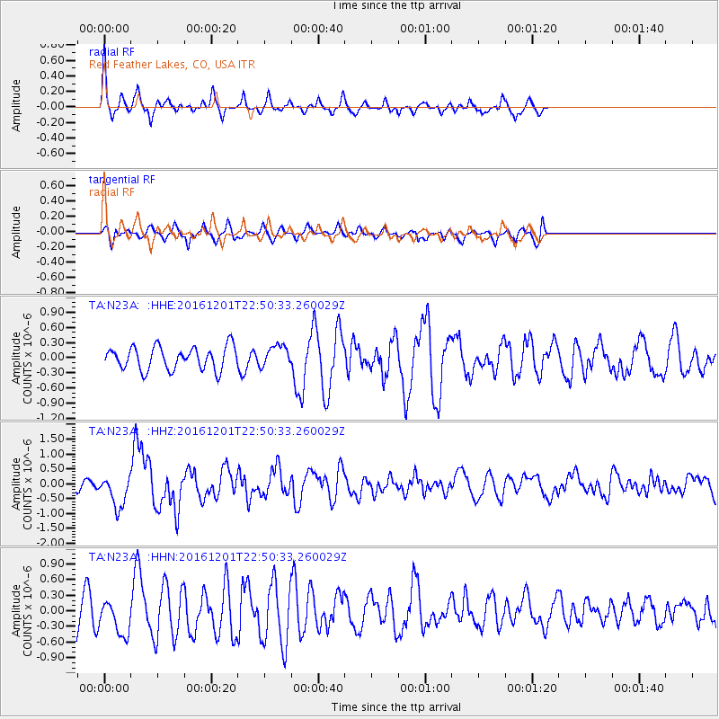
N23A Red Feather Lakes, CO, USA - Earthquake Result Viewer
*The percent match for this event was below the threshold and hence no stack was calculated.
| Earthquake location: |
Southern Peru |
| Earthquake latitude/longitude: |
-15.3/-70.8 |
| Earthquake time(UTC): |
2016/12/01 (336) 22:40:26 GMT |
| Earthquake Depth: |
10 km |
| Earthquake Magnitude: |
6.3 Mww |
| Earthquake Catalog/Contributor: |
NEIC PDE/us |
|
| Network: |
TA USArray Transportable Network (new EarthScope stations) |
| Station: |
N23A Red Feather Lakes, CO, USA |
| Lat/Lon: |
40.89 N/105.94 W |
| Elevation: |
2458 m |
|
| Distance: |
64.7 deg |
| Az: |
331.162 deg |
| Baz: |
142.126 deg |
| Ray Param: |
$rayparam |
*The percent match for this event was below the threshold and hence was not used in the summary stack. |
|
| Radial Match: |
61.181725 % |
| Radial Bump: |
309 |
| Transverse Match: |
57.702957 % |
| Transverse Bump: |
400 |
| SOD ConfigId: |
11737051 |
| Insert Time: |
2019-04-26 04:49:45.243 +0000 |
| GWidth: |
2.5 |
| Max Bumps: |
400 |
| Tol: |
0.001 |
|
Signal To Noise
| Channel | StoN | STA | LTA |
| TA:N23A: :HHZ:20161201T22:50:33.260029Z | 2.653658 | 5.368971E-7 | 2.0232342E-7 |
| TA:N23A: :HHN:20161201T22:50:33.260029Z | 1.0538054 | 3.2622998E-7 | 3.0957327E-7 |
| TA:N23A: :HHE:20161201T22:50:33.260029Z | 0.9230666 | 2.0849915E-7 | 2.258766E-7 |
| Arrivals |
| Ps | |
| PpPs | |
| PsPs/PpSs | |


