You are here: Home > Network List > TA - USArray Transportable Network (new EarthScope stations) Stations List
> Station MSTX Muleshoe, TX, USA > Earthquake Result Viewer
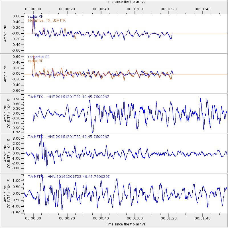
MSTX Muleshoe, TX, USA - Earthquake Result Viewer
*The percent match for this event was below the threshold and hence no stack was calculated.
| Earthquake location: |
Southern Peru |
| Earthquake latitude/longitude: |
-15.3/-70.8 |
| Earthquake time(UTC): |
2016/12/01 (336) 22:40:26 GMT |
| Earthquake Depth: |
10 km |
| Earthquake Magnitude: |
6.3 Mww |
| Earthquake Catalog/Contributor: |
NEIC PDE/us |
|
| Network: |
TA USArray Transportable Network (new EarthScope stations) |
| Station: |
MSTX Muleshoe, TX, USA |
| Lat/Lon: |
33.97 N/102.77 W |
| Elevation: |
1167 m |
|
| Distance: |
57.7 deg |
| Az: |
328.648 deg |
| Baz: |
142.836 deg |
| Ray Param: |
$rayparam |
*The percent match for this event was below the threshold and hence was not used in the summary stack. |
|
| Radial Match: |
76.59196 % |
| Radial Bump: |
390 |
| Transverse Match: |
54.802944 % |
| Transverse Bump: |
400 |
| SOD ConfigId: |
11737051 |
| Insert Time: |
2019-04-26 04:49:45.528 +0000 |
| GWidth: |
2.5 |
| Max Bumps: |
400 |
| Tol: |
0.001 |
|
Signal To Noise
| Channel | StoN | STA | LTA |
| TA:MSTX: :HHZ:20161201T22:49:45.760029Z | 11.582352 | 1.5170415E-6 | 1.3097872E-7 |
| TA:MSTX: :HHN:20161201T22:49:45.760029Z | 2.9884315 | 5.0223065E-7 | 1.6805828E-7 |
| TA:MSTX: :HHE:20161201T22:49:45.760029Z | 2.3499446 | 4.9101504E-7 | 2.089475E-7 |
| Arrivals |
| Ps | |
| PpPs | |
| PsPs/PpSs | |


