You are here: Home > Network List > TX - Texas Seismological Network Stations List
> Station FW12 Venus > Earthquake Result Viewer
FW12 Venus - Earthquake Result Viewer
| Earthquake location: |
Southern Peru |
| Earthquake latitude/longitude: |
-15.3/-70.8 |
| Earthquake time(UTC): |
2016/12/01 (336) 22:40:26 GMT |
| Earthquake Depth: |
10 km |
| Earthquake Magnitude: |
6.3 Mww |
| Earthquake Catalog/Contributor: |
NEIC PDE/us |
|
| Network: |
TX Texas Seismological Network |
| Station: |
FW12 Venus |
| Lat/Lon: |
32.50 N/97.15 W |
| Elevation: |
204 m |
|
| Distance: |
53.8 deg |
| Az: |
332.334 deg |
| Baz: |
147.982 deg |
| Ray Param: |
0.06584793 |
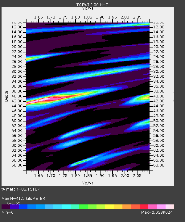
| Estimated Moho Depth: |
41.5 km |
| Estimated Crust Vp/Vs: |
1.65 |
| Assumed Crust Vp: |
6.38 km/s |
| Estimated Crust Vs: |
3.867 km/s |
| Estimated Crust Poisson's Ratio: |
0.21 |
|
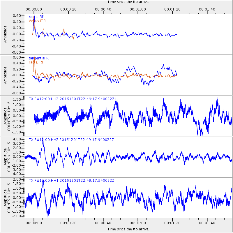
| Radial Match: |
85.15187 % |
| Radial Bump: |
400 |
| Transverse Match: |
58.861153 % |
| Transverse Bump: |
400 |
| SOD ConfigId: |
11737051 |
| Insert Time: |
2019-04-26 04:50:18.067 +0000 |
| GWidth: |
2.5 |
| Max Bumps: |
400 |
| Tol: |
0.001 |
|
Signal To Noise
| Channel | StoN | STA | LTA |
| TX:FW12:00:HHZ:20161201T22:49:17.940022Z | 4.5749598 | 1.234176E-6 | 2.697676E-7 |
| TX:FW12:00:HH1:20161201T22:49:17.940022Z | 1.5543705 | 5.432517E-7 | 3.494995E-7 |
| TX:FW12:00:HH2:20161201T22:49:17.940022Z | 0.9737965 | 4.3988882E-7 | 4.517256E-7 |
| Arrivals |
| Ps | 4.5 SECOND |
| PpPs | 16 SECOND |
| PsPs/PpSs | 21 SECOND |


