You are here: Home > Network List > UW - Pacific Northwest Regional Seismic Network Stations List
> Station UMAT Pilot Rock, OR, USA > Earthquake Result Viewer
UMAT Pilot Rock, OR, USA - Earthquake Result Viewer
*The percent match for this event was below the threshold and hence no stack was calculated.
| Earthquake location: |
Southern Peru |
| Earthquake latitude/longitude: |
-15.3/-70.8 |
| Earthquake time(UTC): |
2016/12/01 (336) 22:40:26 GMT |
| Earthquake Depth: |
10 km |
| Earthquake Magnitude: |
6.3 Mww |
| Earthquake Catalog/Contributor: |
NEIC PDE/us |
|
| Network: |
UW Pacific Northwest Regional Seismic Network |
| Station: |
UMAT Pilot Rock, OR, USA |
| Lat/Lon: |
45.29 N/118.96 W |
| Elevation: |
1318 m |
|
| Distance: |
74.4 deg |
| Az: |
326.923 deg |
| Baz: |
131.754 deg |
| Ray Param: |
$rayparam |
*The percent match for this event was below the threshold and hence was not used in the summary stack. |
|
| Radial Match: |
61.227985 % |
| Radial Bump: |
400 |
| Transverse Match: |
62.342922 % |
| Transverse Bump: |
400 |
| SOD ConfigId: |
11737051 |
| Insert Time: |
2019-04-26 04:50:44.268 +0000 |
| GWidth: |
2.5 |
| Max Bumps: |
400 |
| Tol: |
0.001 |
|
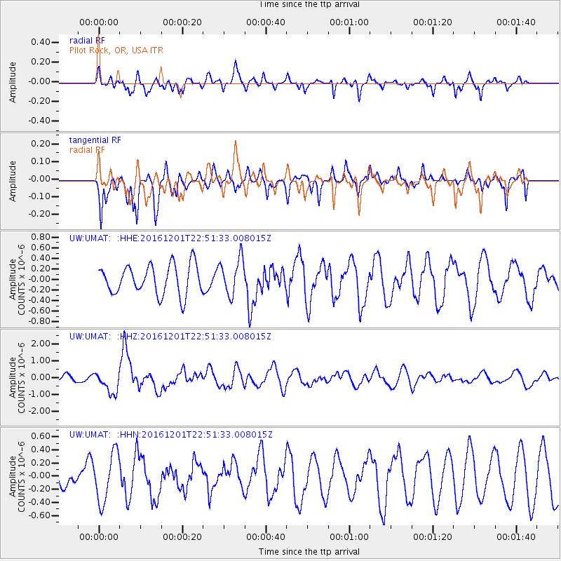
Signal To Noise
| Channel | StoN | STA | LTA |
| UW:UMAT: :HHZ:20161201T22:51:33.008015Z | 3.6159816 | 6.6640195E-7 | 1.8429351E-7 |
| UW:UMAT: :HHN:20161201T22:51:33.008015Z | 1.7233444 | 3.8275812E-7 | 2.2210192E-7 |
| UW:UMAT: :HHE:20161201T22:51:33.008015Z | 1.2316798 | 3.434308E-7 | 2.7883124E-7 |
| Arrivals |
| Ps | |
| PpPs | |
| PsPs/PpSs | |


