You are here: Home > Network List > CI - Caltech Regional Seismic Network Stations List
> Station SCZ2 SCZ2, Santa Cruz Is. (E end), CA, USA > Earthquake Result Viewer
SCZ2 SCZ2, Santa Cruz Is. (E end), CA, USA - Earthquake Result Viewer

| Earthquake location: |
Kermadec Islands Region |
| Earthquake latitude/longitude: |
-27.4/-176.3 |
| Earthquake time(UTC): |
2009/02/18 (049) 21:53:45 GMT |
| Earthquake Depth: |
25 km |
| Earthquake Magnitude: |
6.8 MB, 7.2 MS, 6.9 MW, 6.9 MW |
| Earthquake Catalog/Contributor: |
WHDF/NEIC |
|
| Network: |
CI Caltech Regional Seismic Network |
| Station: |
SCZ2 SCZ2, Santa Cruz Is. (E end), CA, USA |
| Lat/Lon: |
34.00 N/119.64 W |
| Elevation: |
440 m |
|
| Distance: |
81.3 deg |
| Az: |
44.617 deg |
| Baz: |
228.716 deg |
| Ray Param: |
0.04762533 |
| Estimated Moho Depth: |
18.0 km |
| Estimated Crust Vp/Vs: |
1.60 |
| Assumed Crust Vp: |
6.048 km/s |
| Estimated Crust Vs: |
3.78 km/s |
| Estimated Crust Poisson's Ratio: |
0.18 |
|
| Radial Match: |
95.612785 % |
| Radial Bump: |
367 |
| Transverse Match: |
92.493454 % |
| Transverse Bump: |
400 |
| SOD ConfigId: |
2658 |
| Insert Time: |
2010-03-05 20:07:33.828 +0000 |
| GWidth: |
2.5 |
| Max Bumps: |
400 |
| Tol: |
0.001 |
|
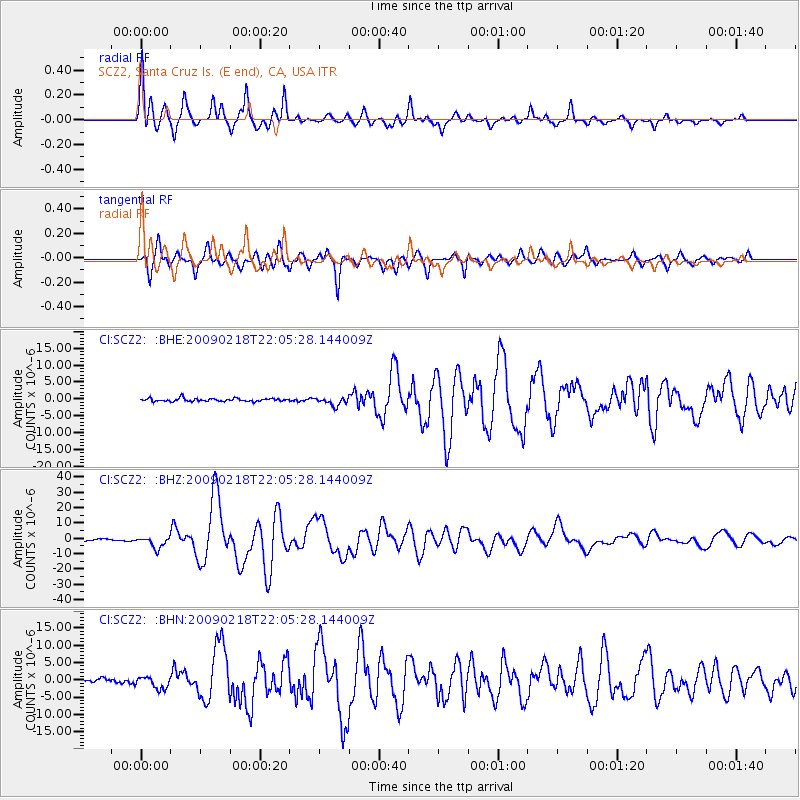
Signal To Noise
| Channel | StoN | STA | LTA |
| CI:SCZ2: :BHZ:20090218T22:05:28.144009Z | 6.5868044 | 3.7564398E-6 | 5.7029774E-7 |
| CI:SCZ2: :BHN:20090218T22:05:28.144009Z | 3.2744062 | 1.783784E-6 | 5.4476567E-7 |
| CI:SCZ2: :BHE:20090218T22:05:28.144009Z | 2.6535997 | 1.2088523E-6 | 4.5555183E-7 |
| Arrivals |
| Ps | 1.8 SECOND |
| PpPs | 7.5 SECOND |
| PsPs/PpSs | 9.4 SECOND |


