You are here: Home > Network List > IM - International Miscellaneous Stations Stations List
> Station TX32 Lajitas Array Site 32 (same as tx01 and TX00) > Earthquake Result Viewer
TX32 Lajitas Array Site 32 (same as tx01 and TX00) - Earthquake Result Viewer
| Earthquake location: |
Near Islands, Aleutian Islands |
| Earthquake latitude/longitude: |
52.2/174.2 |
| Earthquake time(UTC): |
2016/12/03 (338) 09:23:34 GMT |
| Earthquake Depth: |
27 km |
| Earthquake Magnitude: |
6.0 mb |
| Earthquake Catalog/Contributor: |
NEIC PDE/us |
|
| Network: |
IM International Miscellaneous Stations |
| Station: |
TX32 Lajitas Array Site 32 (same as tx01 and TX00) |
| Lat/Lon: |
29.33 N/103.67 W |
| Elevation: |
996 m |
|
| Distance: |
62.7 deg |
| Az: |
76.64 deg |
| Baz: |
316.755 deg |
| Ray Param: |
0.059984013 |
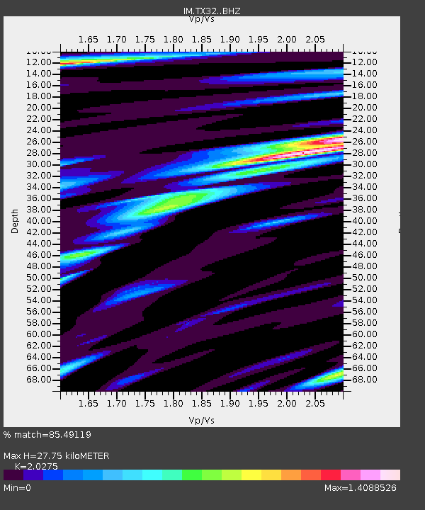
| Estimated Moho Depth: |
27.75 km |
| Estimated Crust Vp/Vs: |
2.03 |
| Assumed Crust Vp: |
6.419 km/s |
| Estimated Crust Vs: |
3.166 km/s |
| Estimated Crust Poisson's Ratio: |
0.34 |
|
| Radial Match: |
85.49119 % |
| Radial Bump: |
400 |
| Transverse Match: |
82.12495 % |
| Transverse Bump: |
400 |
| SOD ConfigId: |
11737051 |
| Insert Time: |
2019-04-26 04:57:10.603 +0000 |
| GWidth: |
2.5 |
| Max Bumps: |
400 |
| Tol: |
0.001 |
|

Signal To Noise
| Channel | StoN | STA | LTA |
| IM:TX32: :BHZ:20161203T09:33:26.748992Z | 6.7163386 | 1.2105742E-6 | 1.8024318E-7 |
| IM:TX32: :BHN:20161203T09:33:26.748992Z | 2.9947195 | 3.4107637E-7 | 1.138926E-7 |
| IM:TX32: :BHE:20161203T09:33:26.748992Z | 3.678363 | 4.489572E-7 | 1.2205354E-7 |
| Arrivals |
| Ps | 4.6 SECOND |
| PpPs | 13 SECOND |
| PsPs/PpSs | 17 SECOND |


