You are here: Home > Network List > JP - Japan Meteorological Agency Seismic Network Stations List
> Station JSU Kagoshima Suzuyama > Earthquake Result Viewer
JSU Kagoshima Suzuyama - Earthquake Result Viewer
| Earthquake location: |
Near Islands, Aleutian Islands |
| Earthquake latitude/longitude: |
52.2/174.2 |
| Earthquake time(UTC): |
2016/12/03 (338) 09:23:34 GMT |
| Earthquake Depth: |
27 km |
| Earthquake Magnitude: |
6.0 mb |
| Earthquake Catalog/Contributor: |
NEIC PDE/us |
|
| Network: |
JP Japan Meteorological Agency Seismic Network |
| Station: |
JSU Kagoshima Suzuyama |
| Lat/Lon: |
31.51 N/130.45 E |
| Elevation: |
400 m |
|
| Distance: |
37.9 deg |
| Az: |
254.23 deg |
| Baz: |
43.852 deg |
| Ray Param: |
0.075851046 |
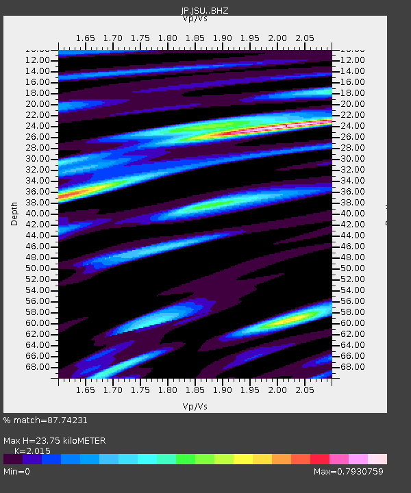
| Estimated Moho Depth: |
23.75 km |
| Estimated Crust Vp/Vs: |
2.02 |
| Assumed Crust Vp: |
6.468 km/s |
| Estimated Crust Vs: |
3.21 km/s |
| Estimated Crust Poisson's Ratio: |
0.34 |
|
| Radial Match: |
87.74231 % |
| Radial Bump: |
341 |
| Transverse Match: |
76.31957 % |
| Transverse Bump: |
400 |
| SOD ConfigId: |
11737051 |
| Insert Time: |
2019-04-26 04:57:27.958 +0000 |
| GWidth: |
2.5 |
| Max Bumps: |
400 |
| Tol: |
0.001 |
|

Signal To Noise
| Channel | StoN | STA | LTA |
| JP:JSU: :BHZ:20161203T09:30:18.850005Z | 20.817406 | 2.5331078E-6 | 1.216822E-7 |
| JP:JSU: :BHN:20161203T09:30:18.850005Z | 9.6430645 | 1.2286691E-6 | 1.274148E-7 |
| JP:JSU: :BHE:20161203T09:30:18.850005Z | 4.939852 | 8.37706E-7 | 1.6958118E-7 |
| Arrivals |
| Ps | 4.0 SECOND |
| PpPs | 10 SECOND |
| PsPs/PpSs | 14 SECOND |


