You are here: Home > Network List > KS - Korea National Seismograph Network- KMA Stations List
> Station NAWB Namwon, South Korea > Earthquake Result Viewer
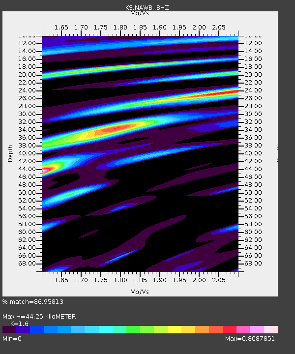
NAWB Namwon, South Korea - Earthquake Result Viewer
| Earthquake location: |
Near Islands, Aleutian Islands |
| Earthquake latitude/longitude: |
52.2/174.2 |
| Earthquake time(UTC): |
2016/12/03 (338) 09:23:34 GMT |
| Earthquake Depth: |
27 km |
| Earthquake Magnitude: |
6.0 mb |
| Earthquake Catalog/Contributor: |
NEIC PDE/us |
|
| Network: |
KS Korea National Seismograph Network- KMA |
| Station: |
NAWB Namwon, South Korea |
| Lat/Lon: |
35.42 N/127.40 E |
| Elevation: |
176 m |
|
| Distance: |
37.0 deg |
| Az: |
261.772 deg |
| Baz: |
48.167 deg |
| Ray Param: |
0.07633834 |
| Estimated Moho Depth: |
44.25 km |
| Estimated Crust Vp/Vs: |
1.60 |
| Assumed Crust Vp: |
6.459 km/s |
| Estimated Crust Vs: |
4.037 km/s |
| Estimated Crust Poisson's Ratio: |
0.18 |
|
| Radial Match: |
86.95813 % |
| Radial Bump: |
380 |
| Transverse Match: |
71.636055 % |
| Transverse Bump: |
400 |
| SOD ConfigId: |
11737051 |
| Insert Time: |
2019-04-26 04:57:46.240 +0000 |
| GWidth: |
2.5 |
| Max Bumps: |
400 |
| Tol: |
0.001 |
|

Signal To Noise
| Channel | StoN | STA | LTA |
| KS:NAWB: :BHZ:20161203T09:30:11.468993Z | 15.530546 | 2.0042398E-6 | 1.2905147E-7 |
| KS:NAWB: :BHN:20161203T09:30:11.468993Z | 11.165659 | 1.0699471E-6 | 9.582481E-8 |
| KS:NAWB: :BHE:20161203T09:30:11.468993Z | 2.1610522 | 2.629683E-7 | 1.216853E-7 |
| Arrivals |
| Ps | 4.5 SECOND |
| PpPs | 16 SECOND |
| PsPs/PpSs | 21 SECOND |


