You are here: Home > Network List > US - United States National Seismic Network Stations List
> Station ELK Elko, Nevada, USA > Earthquake Result Viewer
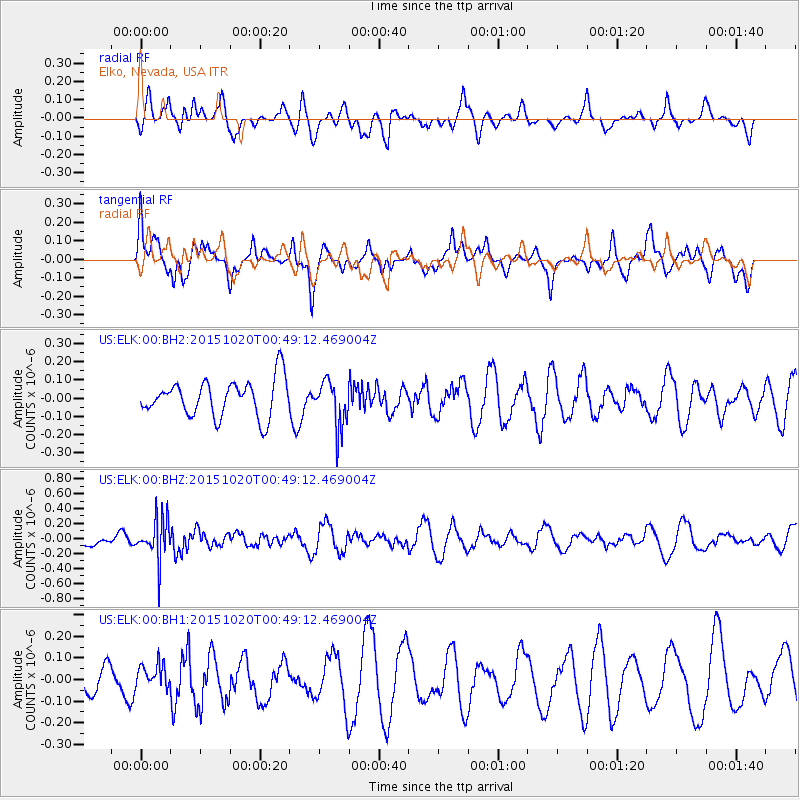
ELK Elko, Nevada, USA - Earthquake Result Viewer
*The percent match for this event was below the threshold and hence no stack was calculated.
| Earthquake location: |
South Of Mariana Islands |
| Earthquake latitude/longitude: |
12.8/143.9 |
| Earthquake time(UTC): |
2015/10/20 (293) 00:36:55 GMT |
| Earthquake Depth: |
93 km |
| Earthquake Magnitude: |
5.6 MB |
| Earthquake Catalog/Contributor: |
NEIC PDE/NEIC COMCAT |
|
| Network: |
US United States National Seismic Network |
| Station: |
ELK Elko, Nevada, USA |
| Lat/Lon: |
40.74 N/115.24 W |
| Elevation: |
2210 m |
|
| Distance: |
89.7 deg |
| Az: |
48.27 deg |
| Baz: |
286.664 deg |
| Ray Param: |
$rayparam |
*The percent match for this event was below the threshold and hence was not used in the summary stack. |
|
| Radial Match: |
41.394733 % |
| Radial Bump: |
400 |
| Transverse Match: |
51.869713 % |
| Transverse Bump: |
400 |
| SOD ConfigId: |
1259291 |
| Insert Time: |
2015-11-03 00:53:01.520 +0000 |
| GWidth: |
2.5 |
| Max Bumps: |
400 |
| Tol: |
0.001 |
|
Signal To Noise
| Channel | StoN | STA | LTA |
| US:ELK:00:BHZ:20151020T00:49:12.469004Z | 2.786111 | 2.8047967E-7 | 1.00670675E-7 |
| US:ELK:00:BH1:20151020T00:49:12.469004Z | 0.6246159 | 5.8581485E-8 | 9.378802E-8 |
| US:ELK:00:BH2:20151020T00:49:12.469004Z | 1.2711611 | 1.2843678E-7 | 1.0103895E-7 |
| Arrivals |
| Ps | |
| PpPs | |
| PsPs/PpSs | |


