You are here: Home > Network List > CI - Caltech Regional Seismic Network Stations List
> Station SCZ2 SCZ2, Santa Cruz Is. (E end), CA, USA > Earthquake Result Viewer
SCZ2 SCZ2, Santa Cruz Is. (E end), CA, USA - Earthquake Result Viewer

| Earthquake location: |
Near West Coast Of Colombia |
| Earthquake latitude/longitude: |
4.7/-77.5 |
| Earthquake time(UTC): |
2004/11/15 (320) 09:06:56 GMT |
| Earthquake Depth: |
15 km |
| Earthquake Magnitude: |
6.6 MB, 7.1 MS, 7.2 MW, 7.1 MW |
| Earthquake Catalog/Contributor: |
WHDF/NEIC |
|
| Network: |
CI Caltech Regional Seismic Network |
| Station: |
SCZ2 SCZ2, Santa Cruz Is. (E end), CA, USA |
| Lat/Lon: |
34.00 N/119.64 W |
| Elevation: |
440 m |
|
| Distance: |
48.7 deg |
| Az: |
312.159 deg |
| Baz: |
117.217 deg |
| Ray Param: |
0.06914281 |
| Estimated Moho Depth: |
36.5 km |
| Estimated Crust Vp/Vs: |
1.68 |
| Assumed Crust Vp: |
6.048 km/s |
| Estimated Crust Vs: |
3.611 km/s |
| Estimated Crust Poisson's Ratio: |
0.22 |
|
| Radial Match: |
95.30566 % |
| Radial Bump: |
302 |
| Transverse Match: |
91.16116 % |
| Transverse Bump: |
400 |
| SOD ConfigId: |
2459 |
| Insert Time: |
2010-03-05 20:08:55.909 +0000 |
| GWidth: |
2.5 |
| Max Bumps: |
400 |
| Tol: |
0.001 |
|
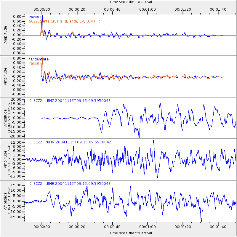
Signal To Noise
| Channel | StoN | STA | LTA |
| CI:SCZ2: :BHN:20041115T09:15:09.595004Z | 3.2650187 | 1.938754E-6 | 5.937957E-7 |
| CI:SCZ2: :BHE:20041115T09:15:09.595004Z | 5.68156 | 4.454308E-6 | 7.839938E-7 |
| CI:SCZ2: :BHZ:20041115T09:15:09.595004Z | 11.891275 | 7.0153596E-6 | 5.899586E-7 |
| Arrivals |
| Ps | 4.3 SECOND |
| PpPs | 15 SECOND |
| PsPs/PpSs | 20 SECOND |


