You are here: Home > Network List > CI - Caltech Regional Seismic Network Stations List
> Station SCZ2 SCZ2, Santa Cruz Is. (E end), CA, USA > Earthquake Result Viewer
SCZ2 SCZ2, Santa Cruz Is. (E end), CA, USA - Earthquake Result Viewer

| Earthquake location: |
Santiago Del Estero Prov., Arg. |
| Earthquake latitude/longitude: |
-28.6/-65.8 |
| Earthquake time(UTC): |
2004/09/07 (251) 11:53:06 GMT |
| Earthquake Depth: |
22 km |
| Earthquake Magnitude: |
6.1 MB, 6.1 MS, 6.4 MW, 6.2 MW |
| Earthquake Catalog/Contributor: |
WHDF/NEIC |
|
| Network: |
CI Caltech Regional Seismic Network |
| Station: |
SCZ2 SCZ2, Santa Cruz Is. (E end), CA, USA |
| Lat/Lon: |
34.00 N/119.64 W |
| Elevation: |
440 m |
|
| Distance: |
80.4 deg |
| Az: |
317.162 deg |
| Baz: |
133.962 deg |
| Ray Param: |
0.048281953 |
| Estimated Moho Depth: |
16.5 km |
| Estimated Crust Vp/Vs: |
1.71 |
| Assumed Crust Vp: |
6.048 km/s |
| Estimated Crust Vs: |
3.532 km/s |
| Estimated Crust Poisson's Ratio: |
0.24 |
|
| Radial Match: |
80.931816 % |
| Radial Bump: |
400 |
| Transverse Match: |
78.98833 % |
| Transverse Bump: |
400 |
| SOD ConfigId: |
2459 |
| Insert Time: |
2010-03-05 20:08:59.452 +0000 |
| GWidth: |
2.5 |
| Max Bumps: |
400 |
| Tol: |
0.001 |
|
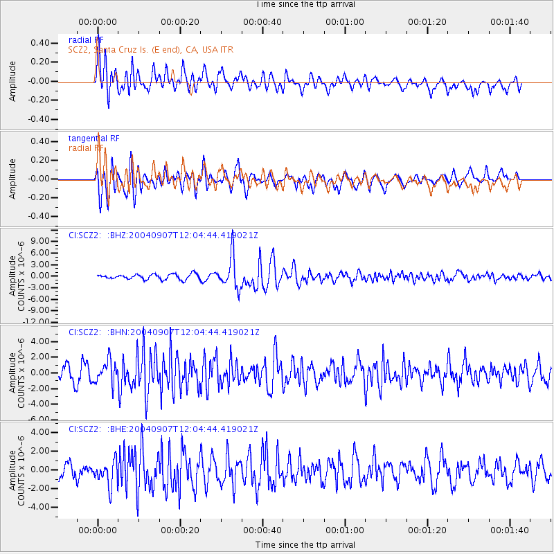
Signal To Noise
| Channel | StoN | STA | LTA |
| CI:SCZ2: :BHN:20040907T12:04:44.419021Z | 1.8770546 | 1.439492E-6 | 7.668887E-7 |
| CI:SCZ2: :BHE:20040907T12:04:44.419021Z | 2.1871667 | 1.3675362E-6 | 6.2525476E-7 |
| CI:SCZ2: :BHZ:20040907T12:04:44.419021Z | 6.3934855 | 4.2910783E-6 | 6.711642E-7 |
| Arrivals |
| Ps | 2.0 SECOND |
| PpPs | 7.2 SECOND |
| PsPs/PpSs | 9.2 SECOND |


