You are here: Home > Network List > TA - USArray Transportable Network (new EarthScope stations) Stations List
> Station 833A Chaparral WMA, Artesia Wells, TX, USA > Earthquake Result Viewer
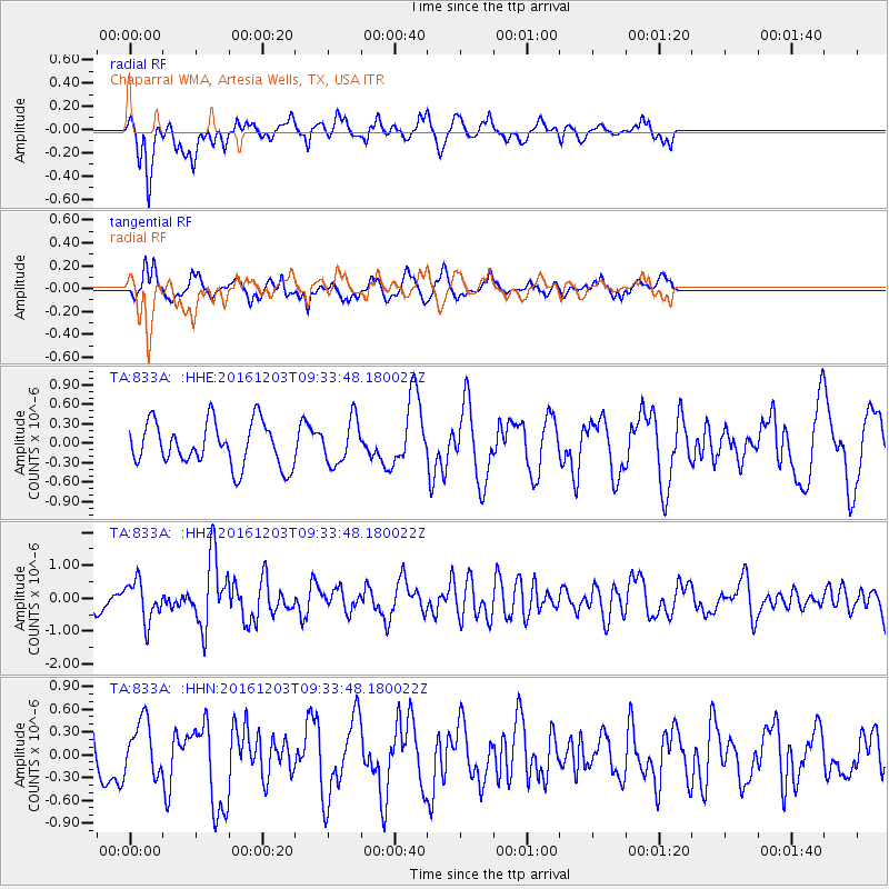
833A Chaparral WMA, Artesia Wells, TX, USA - Earthquake Result Viewer
*The percent match for this event was below the threshold and hence no stack was calculated.
| Earthquake location: |
Near Islands, Aleutian Islands |
| Earthquake latitude/longitude: |
52.2/174.2 |
| Earthquake time(UTC): |
2016/12/03 (338) 09:23:34 GMT |
| Earthquake Depth: |
27 km |
| Earthquake Magnitude: |
6.0 mb |
| Earthquake Catalog/Contributor: |
NEIC PDE/us |
|
| Network: |
TA USArray Transportable Network (new EarthScope stations) |
| Station: |
833A Chaparral WMA, Artesia Wells, TX, USA |
| Lat/Lon: |
28.32 N/99.39 W |
| Elevation: |
171 m |
|
| Distance: |
66.0 deg |
| Az: |
74.343 deg |
| Baz: |
317.812 deg |
| Ray Param: |
$rayparam |
*The percent match for this event was below the threshold and hence was not used in the summary stack. |
|
| Radial Match: |
62.277985 % |
| Radial Bump: |
400 |
| Transverse Match: |
59.904114 % |
| Transverse Bump: |
361 |
| SOD ConfigId: |
11737051 |
| Insert Time: |
2019-04-26 05:02:36.524 +0000 |
| GWidth: |
2.5 |
| Max Bumps: |
400 |
| Tol: |
0.001 |
|
Signal To Noise
| Channel | StoN | STA | LTA |
| TA:833A: :HHZ:20161203T09:33:48.180022Z | 1.5912029 | 6.0066907E-7 | 3.7749368E-7 |
| TA:833A: :HHN:20161203T09:33:48.180022Z | 0.69532365 | 3.4882126E-7 | 5.0166744E-7 |
| TA:833A: :HHE:20161203T09:33:48.180022Z | 1.0125779 | 3.3908367E-7 | 3.348717E-7 |
| Arrivals |
| Ps | |
| PpPs | |
| PsPs/PpSs | |


