You are here: Home > Network List > CI - Caltech Regional Seismic Network Stations List
> Station SDD Saddleback, Mission Viejo, CA, USA > Earthquake Result Viewer
SDD Saddleback, Mission Viejo, CA, USA - Earthquake Result Viewer

| Earthquake location: |
Kuril Islands |
| Earthquake latitude/longitude: |
46.6/153.3 |
| Earthquake time(UTC): |
2006/11/15 (319) 11:14:13 GMT |
| Earthquake Depth: |
10 km |
| Earthquake Magnitude: |
6.5 MB, 7.8 MS, 8.3 MW, 7.9 MW |
| Earthquake Catalog/Contributor: |
WHDF/NEIC |
|
| Network: |
CI Caltech Regional Seismic Network |
| Station: |
SDD Saddleback, Mission Viejo, CA, USA |
| Lat/Lon: |
33.55 N/117.66 W |
| Elevation: |
120 m |
|
| Distance: |
65.9 deg |
| Az: |
66.124 deg |
| Baz: |
310.962 deg |
| Ray Param: |
0.05794279 |
| Estimated Moho Depth: |
45.5 km |
| Estimated Crust Vp/Vs: |
2.10 |
| Assumed Crust Vp: |
6.264 km/s |
| Estimated Crust Vs: |
2.986 km/s |
| Estimated Crust Poisson's Ratio: |
0.35 |
|
| Radial Match: |
92.04675 % |
| Radial Bump: |
400 |
| Transverse Match: |
82.881935 % |
| Transverse Bump: |
400 |
| SOD ConfigId: |
2564 |
| Insert Time: |
2010-02-26 00:54:42.833 +0000 |
| GWidth: |
2.5 |
| Max Bumps: |
400 |
| Tol: |
0.001 |
|
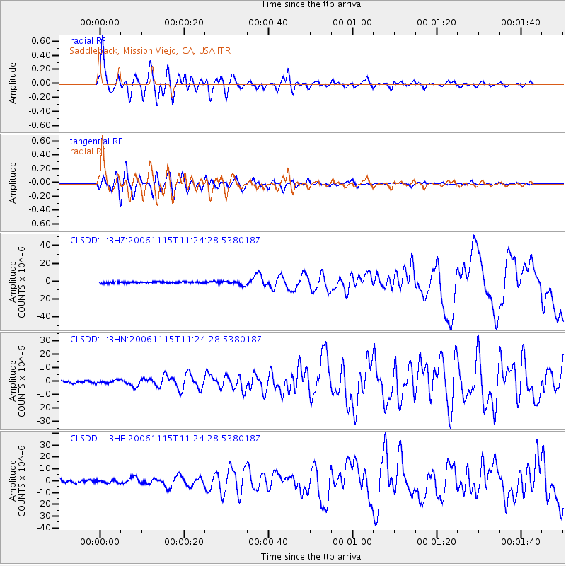
Signal To Noise
| Channel | StoN | STA | LTA |
| CI:SDD: :BHN:20061115T11:24:28.538018Z | 1.7275091 | 1.1847677E-6 | 6.8582426E-7 |
| CI:SDD: :BHE:20061115T11:24:28.538018Z | 0.9478171 | 1.095428E-6 | 1.1557379E-6 |
| CI:SDD: :BHZ:20061115T11:24:28.538018Z | 3.2676966 | 2.2951504E-6 | 7.023756E-7 |
| Arrivals |
| Ps | 8.2 SECOND |
| PpPs | 22 SECOND |
| PsPs/PpSs | 30 SECOND |


