You are here: Home > Network List > CI - Caltech Regional Seismic Network Stations List
> Station SDD Saddleback, Mission Viejo, CA, USA > Earthquake Result Viewer
SDD Saddleback, Mission Viejo, CA, USA - Earthquake Result Viewer
| Earthquake location: |
Samoa Islands Region |
| Earthquake latitude/longitude: |
-16.6/-172.0 |
| Earthquake time(UTC): |
2006/09/28 (271) 06:22:09 GMT |
| Earthquake Depth: |
28 km |
| Earthquake Magnitude: |
6.5 MB, 6.6 MS, 6.9 MW, 6.7 MW |
| Earthquake Catalog/Contributor: |
WHDF/NEIC |
|
| Network: |
CI Caltech Regional Seismic Network |
| Station: |
SDD Saddleback, Mission Viejo, CA, USA |
| Lat/Lon: |
33.55 N/117.66 W |
| Elevation: |
120 m |
|
| Distance: |
71.9 deg |
| Az: |
45.563 deg |
| Baz: |
235.072 deg |
| Ray Param: |
0.05396769 |
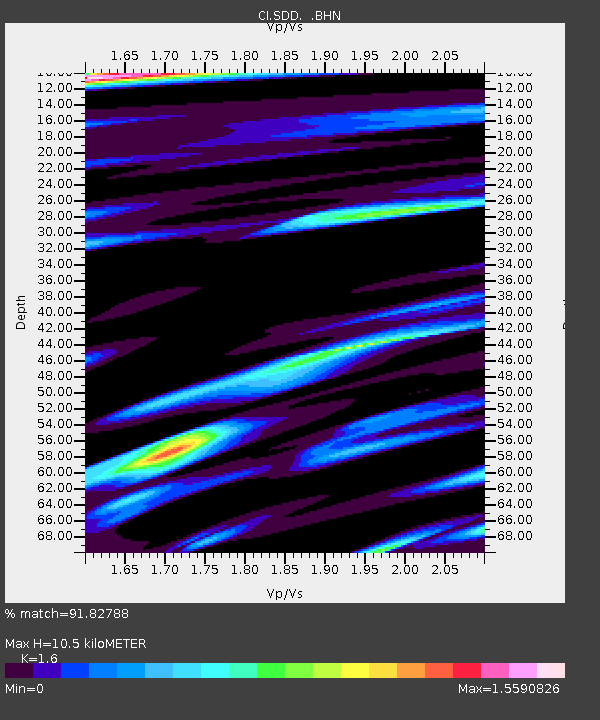
| Estimated Moho Depth: |
10.5 km |
| Estimated Crust Vp/Vs: |
1.60 |
| Assumed Crust Vp: |
6.264 km/s |
| Estimated Crust Vs: |
3.915 km/s |
| Estimated Crust Poisson's Ratio: |
0.18 |
|
| Radial Match: |
91.82788 % |
| Radial Bump: |
400 |
| Transverse Match: |
89.60858 % |
| Transverse Bump: |
400 |
| SOD ConfigId: |
2564 |
| Insert Time: |
2010-02-26 00:54:44.975 +0000 |
| GWidth: |
2.5 |
| Max Bumps: |
400 |
| Tol: |
0.001 |
|
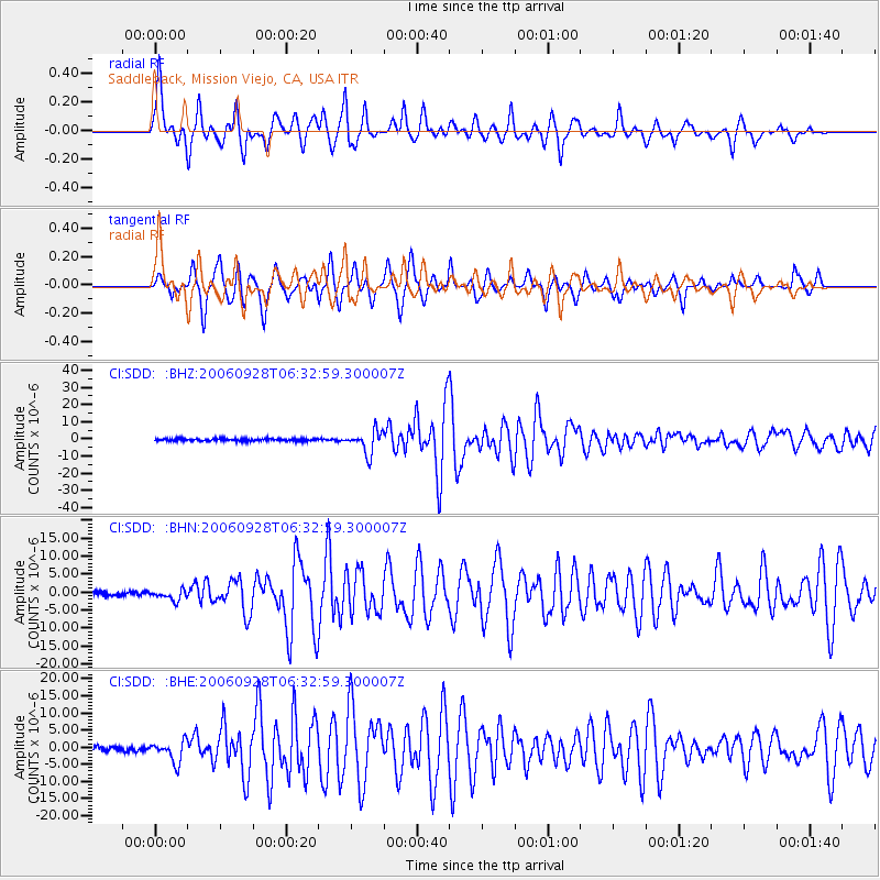
Signal To Noise
| Channel | StoN | STA | LTA |
| CI:SDD: :BHN:20060928T06:32:59.300007Z | 2.381513 | 1.4142794E-6 | 5.9385746E-7 |
| CI:SDD: :BHE:20060928T06:32:59.300007Z | 4.474099 | 3.0700548E-6 | 6.8618397E-7 |
| CI:SDD: :BHZ:20060928T06:32:59.300007Z | 10.065197 | 6.5845175E-6 | 6.5418664E-7 |
| Arrivals |
| Ps | 1.0 SECOND |
| PpPs | 4.2 SECOND |
| PsPs/PpSs | 5.2 SECOND |


