You are here: Home > Network List > TA - USArray Transportable Network (new EarthScope stations) Stations List
> Station A21K Barrow, AK, USA > Earthquake Result Viewer
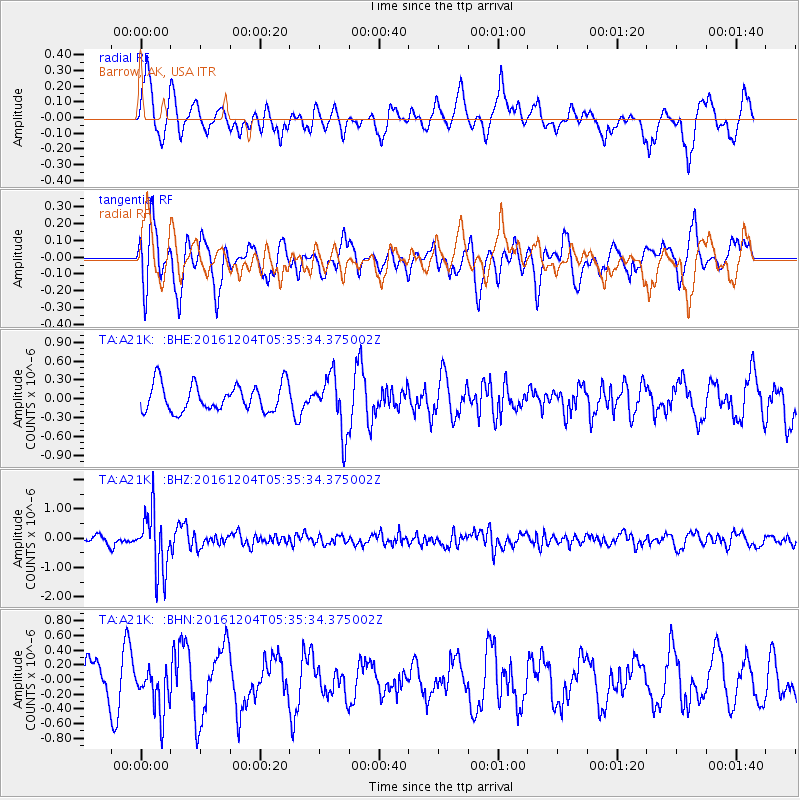
A21K Barrow, AK, USA - Earthquake Result Viewer
*The percent match for this event was below the threshold and hence no stack was calculated.
| Earthquake location: |
Talaud Islands, Indonesia |
| Earthquake latitude/longitude: |
4.5/127.8 |
| Earthquake time(UTC): |
2016/12/04 (339) 05:24:05 GMT |
| Earthquake Depth: |
142 km |
| Earthquake Magnitude: |
5.7 mb |
| Earthquake Catalog/Contributor: |
NEIC PDE/us |
|
| Network: |
TA USArray Transportable Network (new EarthScope stations) |
| Station: |
A21K Barrow, AK, USA |
| Lat/Lon: |
71.32 N/156.62 W |
| Elevation: |
577 m |
|
| Distance: |
81.1 deg |
| Az: |
18.406 deg |
| Baz: |
257.704 deg |
| Ray Param: |
$rayparam |
*The percent match for this event was below the threshold and hence was not used in the summary stack. |
|
| Radial Match: |
61.290066 % |
| Radial Bump: |
367 |
| Transverse Match: |
67.34178 % |
| Transverse Bump: |
397 |
| SOD ConfigId: |
11737051 |
| Insert Time: |
2019-04-26 05:17:12.539 +0000 |
| GWidth: |
2.5 |
| Max Bumps: |
400 |
| Tol: |
0.001 |
|
Signal To Noise
| Channel | StoN | STA | LTA |
| TA:A21K: :BHZ:20161204T05:35:34.375002Z | 6.9644094 | 1.0227382E-6 | 1.4685212E-7 |
| TA:A21K: :BHN:20161204T05:35:34.375002Z | 1.2070872 | 3.1757193E-7 | 2.6308948E-7 |
| TA:A21K: :BHE:20161204T05:35:34.375002Z | 2.0649107 | 4.4558246E-7 | 2.1578778E-7 |
| Arrivals |
| Ps | |
| PpPs | |
| PsPs/PpSs | |


