You are here: Home > Network List > TA - USArray Transportable Network (new EarthScope stations) Stations List
> Station J20K Nowitna River, AK, USA > Earthquake Result Viewer
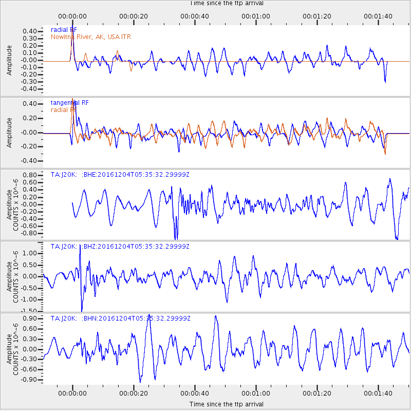
J20K Nowitna River, AK, USA - Earthquake Result Viewer
*The percent match for this event was below the threshold and hence no stack was calculated.
| Earthquake location: |
Talaud Islands, Indonesia |
| Earthquake latitude/longitude: |
4.5/127.8 |
| Earthquake time(UTC): |
2016/12/04 (339) 05:24:05 GMT |
| Earthquake Depth: |
142 km |
| Earthquake Magnitude: |
5.7 mb |
| Earthquake Catalog/Contributor: |
NEIC PDE/us |
|
| Network: |
TA USArray Transportable Network (new EarthScope stations) |
| Station: |
J20K Nowitna River, AK, USA |
| Lat/Lon: |
64.18 N/154.15 W |
| Elevation: |
314 m |
|
| Distance: |
80.8 deg |
| Az: |
25.726 deg |
| Baz: |
261.146 deg |
| Ray Param: |
$rayparam |
*The percent match for this event was below the threshold and hence was not used in the summary stack. |
|
| Radial Match: |
59.386295 % |
| Radial Bump: |
399 |
| Transverse Match: |
46.146683 % |
| Transverse Bump: |
400 |
| SOD ConfigId: |
11737051 |
| Insert Time: |
2019-04-26 05:17:27.170 +0000 |
| GWidth: |
2.5 |
| Max Bumps: |
400 |
| Tol: |
0.001 |
|
Signal To Noise
| Channel | StoN | STA | LTA |
| TA:J20K: :BHZ:20161204T05:35:32.29999Z | 2.5036423 | 6.040513E-7 | 2.4126902E-7 |
| TA:J20K: :BHN:20161204T05:35:32.29999Z | 0.47560656 | 1.766741E-7 | 3.7147112E-7 |
| TA:J20K: :BHE:20161204T05:35:32.29999Z | 1.9273396 | 4.246921E-7 | 2.2035147E-7 |
| Arrivals |
| Ps | |
| PpPs | |
| PsPs/PpSs | |


