You are here: Home > Network List > IU - Global Seismograph Network (GSN - IRIS/USGS) Stations List
> Station RSSD Black Hills, South Dakota, USA > Earthquake Result Viewer
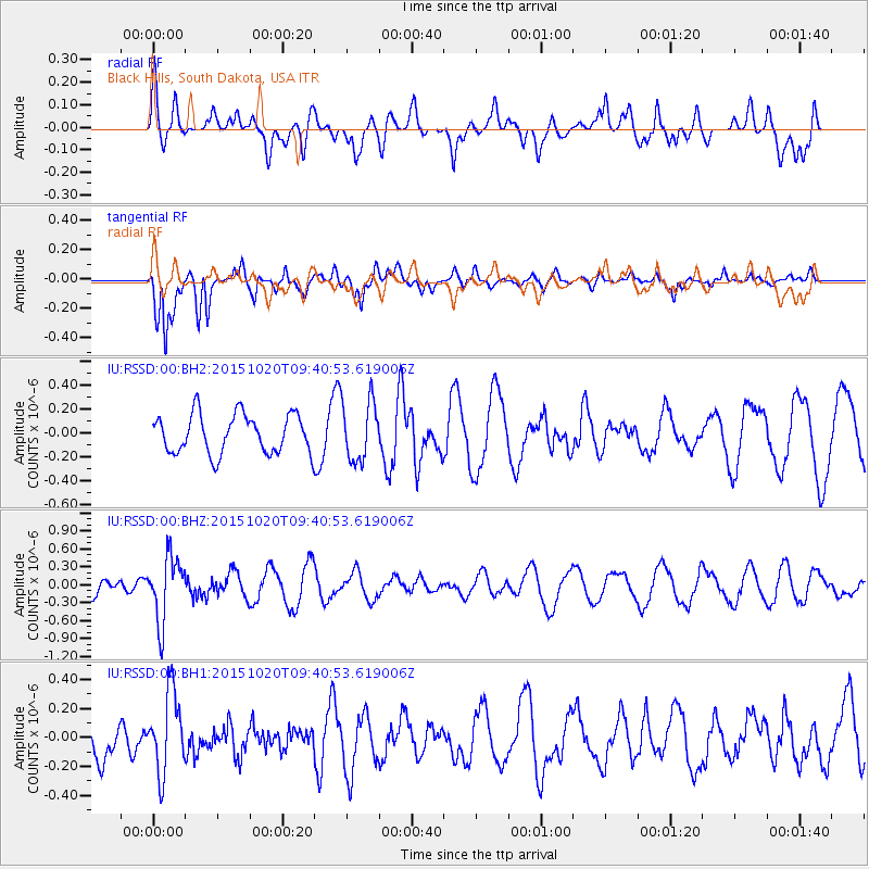
RSSD Black Hills, South Dakota, USA - Earthquake Result Viewer
*The percent match for this event was below the threshold and hence no stack was calculated.
| Earthquake location: |
Bonin Islands, Japan Region |
| Earthquake latitude/longitude: |
27.0/140.3 |
| Earthquake time(UTC): |
2015/10/20 (293) 09:29:08 GMT |
| Earthquake Depth: |
300 km |
| Earthquake Magnitude: |
5.5 MB |
| Earthquake Catalog/Contributor: |
NEIC PDE/NEIC COMCAT |
|
| Network: |
IU Global Seismograph Network (GSN - IRIS/USGS) |
| Station: |
RSSD Black Hills, South Dakota, USA |
| Lat/Lon: |
44.12 N/104.04 W |
| Elevation: |
2090 m |
|
| Distance: |
88.0 deg |
| Az: |
40.492 deg |
| Baz: |
306.465 deg |
| Ray Param: |
$rayparam |
*The percent match for this event was below the threshold and hence was not used in the summary stack. |
|
| Radial Match: |
48.494762 % |
| Radial Bump: |
400 |
| Transverse Match: |
79.75098 % |
| Transverse Bump: |
400 |
| SOD ConfigId: |
1259291 |
| Insert Time: |
2015-11-03 10:08:08.431 +0000 |
| GWidth: |
2.5 |
| Max Bumps: |
400 |
| Tol: |
0.001 |
|
Signal To Noise
| Channel | StoN | STA | LTA |
| IU:RSSD:00:BHZ:20151020T09:40:53.619006Z | 2.5456579 | 5.3561274E-7 | 2.1040249E-7 |
| IU:RSSD:00:BH1:20151020T09:40:53.619006Z | 2.2109172 | 2.7495568E-7 | 1.2436273E-7 |
| IU:RSSD:00:BH2:20151020T09:40:53.619006Z | 1.5340757 | 2.500596E-7 | 1.6300342E-7 |
| Arrivals |
| Ps | |
| PpPs | |
| PsPs/PpSs | |


