You are here: Home > Network List > CB - China National Seismic Network Stations List
> Station GZH Guangzhou,Guangdong Province > Earthquake Result Viewer
GZH Guangzhou,Guangdong Province - Earthquake Result Viewer
| Earthquake location: |
Banda Sea |
| Earthquake latitude/longitude: |
-7.3/123.4 |
| Earthquake time(UTC): |
2016/12/05 (340) 01:13:04 GMT |
| Earthquake Depth: |
526 km |
| Earthquake Magnitude: |
6.3 Mww |
| Earthquake Catalog/Contributor: |
NEIC PDE/us |
|
| Network: |
CB China National Seismic Network |
| Station: |
GZH Guangzhou,Guangdong Province |
| Lat/Lon: |
23.65 N/113.65 E |
| Elevation: |
65 m |
|
| Distance: |
32.2 deg |
| Az: |
343.103 deg |
| Baz: |
161.674 deg |
| Ray Param: |
0.07641161 |
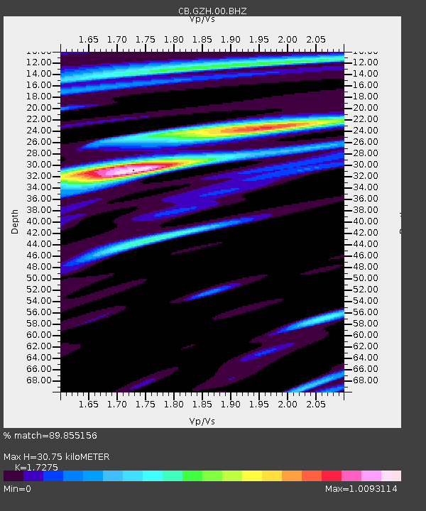
| Estimated Moho Depth: |
30.75 km |
| Estimated Crust Vp/Vs: |
1.73 |
| Assumed Crust Vp: |
6.276 km/s |
| Estimated Crust Vs: |
3.633 km/s |
| Estimated Crust Poisson's Ratio: |
0.25 |
|
| Radial Match: |
89.855156 % |
| Radial Bump: |
370 |
| Transverse Match: |
61.49426 % |
| Transverse Bump: |
400 |
| SOD ConfigId: |
11737051 |
| Insert Time: |
2019-04-26 05:20:23.152 +0000 |
| GWidth: |
2.5 |
| Max Bumps: |
400 |
| Tol: |
0.001 |
|

Signal To Noise
| Channel | StoN | STA | LTA |
| CB:GZH:00:BHZ:20161205T01:18:19.080012Z | 25.516014 | 2.8596844E-6 | 1.1207411E-7 |
| CB:GZH:00:BHN:20161205T01:18:19.080012Z | 21.329458 | 1.5272399E-6 | 7.160238E-8 |
| CB:GZH:00:BHE:20161205T01:18:19.080012Z | 5.911315 | 4.5368583E-7 | 7.674871E-8 |
| Arrivals |
| Ps | 3.8 SECOND |
| PpPs | 12 SECOND |
| PsPs/PpSs | 16 SECOND |


