You are here: Home > Network List > CB - China National Seismic Network Stations List
> Station HEH Heihe,Heilongjiang Province > Earthquake Result Viewer
HEH Heihe,Heilongjiang Province - Earthquake Result Viewer

| Earthquake location: |
Banda Sea |
| Earthquake latitude/longitude: |
-7.3/123.4 |
| Earthquake time(UTC): |
2016/12/05 (340) 01:13:04 GMT |
| Earthquake Depth: |
526 km |
| Earthquake Magnitude: |
6.3 Mww |
| Earthquake Catalog/Contributor: |
NEIC PDE/us |
|
| Network: |
CB China National Seismic Network |
| Station: |
HEH Heihe,Heilongjiang Province |
| Lat/Lon: |
50.25 N/127.41 E |
| Elevation: |
165 m |
|
| Distance: |
57.4 deg |
| Az: |
3.068 deg |
| Baz: |
184.744 deg |
| Ray Param: |
0.06137466 |
| Estimated Moho Depth: |
32.0 km |
| Estimated Crust Vp/Vs: |
1.81 |
| Assumed Crust Vp: |
6.419 km/s |
| Estimated Crust Vs: |
3.547 km/s |
| Estimated Crust Poisson's Ratio: |
0.28 |
|
| Radial Match: |
95.23451 % |
| Radial Bump: |
345 |
| Transverse Match: |
90.22287 % |
| Transverse Bump: |
400 |
| SOD ConfigId: |
11737051 |
| Insert Time: |
2019-04-26 05:20:25.524 +0000 |
| GWidth: |
2.5 |
| Max Bumps: |
400 |
| Tol: |
0.001 |
|
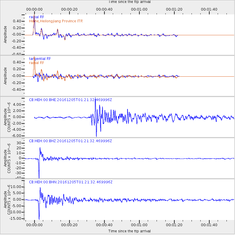
Signal To Noise
| Channel | StoN | STA | LTA |
| CB:HEH:00:BHZ:20161205T01:21:32.469996Z | 85.58916 | 1.1272948E-5 | 1.3171E-7 |
| CB:HEH:00:BHN:20161205T01:21:32.469996Z | 18.77411 | 4.665462E-6 | 2.4850507E-7 |
| CB:HEH:00:BHE:20161205T01:21:32.469996Z | 9.05604 | 1.1557329E-6 | 1.2762011E-7 |
| Arrivals |
| Ps | 4.2 SECOND |
| PpPs | 13 SECOND |
| PsPs/PpSs | 18 SECOND |


