You are here: Home > Network List > CI - Caltech Regional Seismic Network Stations List
> Station FUR Furnace Creek, CA, USA > Earthquake Result Viewer
FUR Furnace Creek, CA, USA - Earthquake Result Viewer
| Earthquake location: |
Near West Coast Of Honshu, Japan |
| Earthquake latitude/longitude: |
37.2/138.8 |
| Earthquake time(UTC): |
2004/10/23 (297) 08:56:00 GMT |
| Earthquake Depth: |
16 km |
| Earthquake Magnitude: |
6.4 MB, 6.3 MS, 6.6 MW, 6.4 MW |
| Earthquake Catalog/Contributor: |
WHDF/NEIC |
|
| Network: |
CI Caltech Regional Seismic Network |
| Station: |
FUR Furnace Creek, CA, USA |
| Lat/Lon: |
36.47 N/116.86 W |
| Elevation: |
-37.0 m |
|
| Distance: |
78.6 deg |
| Az: |
52.799 deg |
| Baz: |
307.934 deg |
| Ray Param: |
0.049491063 |
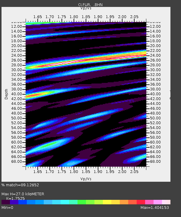
| Estimated Moho Depth: |
27.0 km |
| Estimated Crust Vp/Vs: |
1.75 |
| Assumed Crust Vp: |
6.279 km/s |
| Estimated Crust Vs: |
3.583 km/s |
| Estimated Crust Poisson's Ratio: |
0.26 |
|
| Radial Match: |
89.12652 % |
| Radial Bump: |
400 |
| Transverse Match: |
89.0821 % |
| Transverse Bump: |
400 |
| SOD ConfigId: |
2459 |
| Insert Time: |
2010-03-05 20:11:04.534 +0000 |
| GWidth: |
2.5 |
| Max Bumps: |
400 |
| Tol: |
0.001 |
|
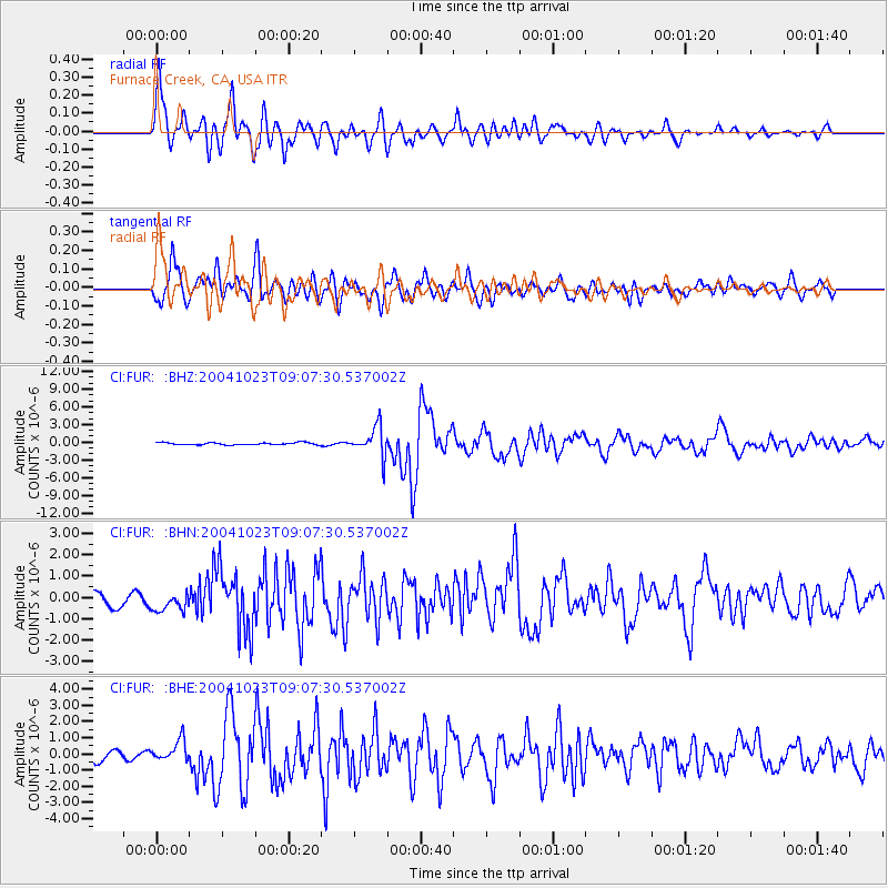
Signal To Noise
| Channel | StoN | STA | LTA |
| CI:FUR: :BHN:20041023T09:07:30.537002Z | 1.3341434 | 4.5731974E-7 | 3.4278153E-7 |
| CI:FUR: :BHE:20041023T09:07:30.537002Z | 2.615672 | 6.479263E-7 | 2.477093E-7 |
| CI:FUR: :BHZ:20041023T09:07:30.537002Z | 13.413592 | 2.4303924E-6 | 1.8118878E-7 |
| Arrivals |
| Ps | 3.3 SECOND |
| PpPs | 12 SECOND |
| PsPs/PpSs | 15 SECOND |


