You are here: Home > Network List > JP - Japan Meteorological Agency Seismic Network Stations List
> Station JCJ Chichijima Island > Earthquake Result Viewer
JCJ Chichijima Island - Earthquake Result Viewer
| Earthquake location: |
Banda Sea |
| Earthquake latitude/longitude: |
-7.3/123.4 |
| Earthquake time(UTC): |
2016/12/05 (340) 01:13:04 GMT |
| Earthquake Depth: |
526 km |
| Earthquake Magnitude: |
6.3 Mww |
| Earthquake Catalog/Contributor: |
NEIC PDE/us |
|
| Network: |
JP Japan Meteorological Agency Seismic Network |
| Station: |
JCJ Chichijima Island |
| Lat/Lon: |
27.10 N/142.18 E |
| Elevation: |
150 m |
|
| Distance: |
38.8 deg |
| Az: |
27.324 deg |
| Baz: |
210.715 deg |
| Ray Param: |
0.07280318 |
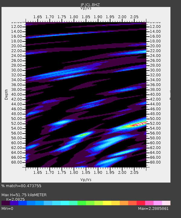
| Estimated Moho Depth: |
51.75 km |
| Estimated Crust Vp/Vs: |
2.08 |
| Assumed Crust Vp: |
4.24 km/s |
| Estimated Crust Vs: |
2.036 km/s |
| Estimated Crust Poisson's Ratio: |
0.35 |
|
| Radial Match: |
80.473755 % |
| Radial Bump: |
400 |
| Transverse Match: |
64.40691 % |
| Transverse Bump: |
400 |
| SOD ConfigId: |
11737051 |
| Insert Time: |
2019-04-26 05:21:04.365 +0000 |
| GWidth: |
2.5 |
| Max Bumps: |
400 |
| Tol: |
0.001 |
|

Signal To Noise
| Channel | StoN | STA | LTA |
| JP:JCJ: :BHZ:20161205T01:19:13.350001Z | 16.781164 | 1.504915E-5 | 8.9678815E-7 |
| JP:JCJ: :BHN:20161205T01:19:13.350001Z | 6.5357103 | 6.1299615E-6 | 9.379182E-7 |
| JP:JCJ: :BHE:20161205T01:19:13.350001Z | 6.508592 | 5.8046357E-6 | 8.9184203E-7 |
| Arrivals |
| Ps | 14 SECOND |
| PpPs | 37 SECOND |
| PsPs/PpSs | 50 SECOND |


