You are here: Home > Network List > CI - Caltech Regional Seismic Network Stations List
> Station FUR Furnace Creek, CA, USA > Earthquake Result Viewer
FUR Furnace Creek, CA, USA - Earthquake Result Viewer
| Earthquake location: |
Santiago Del Estero Prov., Arg. |
| Earthquake latitude/longitude: |
-28.6/-65.8 |
| Earthquake time(UTC): |
2004/09/07 (251) 11:53:06 GMT |
| Earthquake Depth: |
22 km |
| Earthquake Magnitude: |
6.1 MB, 6.1 MS, 6.4 MW, 6.2 MW |
| Earthquake Catalog/Contributor: |
WHDF/NEIC |
|
| Network: |
CI Caltech Regional Seismic Network |
| Station: |
FUR Furnace Creek, CA, USA |
| Lat/Lon: |
36.47 N/116.86 W |
| Elevation: |
-37.0 m |
|
| Distance: |
80.5 deg |
| Az: |
320.557 deg |
| Baz: |
136.116 deg |
| Ray Param: |
0.048185747 |
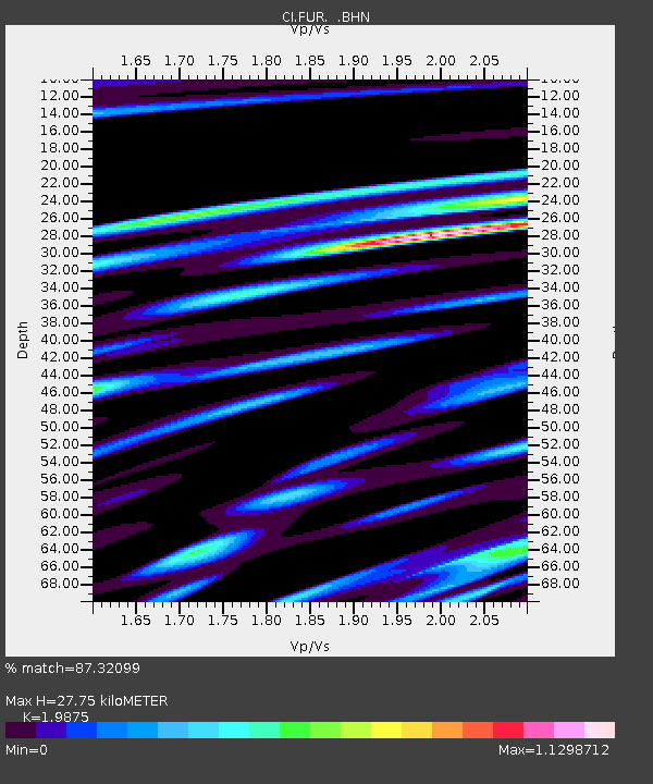
| Estimated Moho Depth: |
27.75 km |
| Estimated Crust Vp/Vs: |
1.99 |
| Assumed Crust Vp: |
6.279 km/s |
| Estimated Crust Vs: |
3.159 km/s |
| Estimated Crust Poisson's Ratio: |
0.33 |
|
| Radial Match: |
87.32099 % |
| Radial Bump: |
400 |
| Transverse Match: |
83.29011 % |
| Transverse Bump: |
400 |
| SOD ConfigId: |
2459 |
| Insert Time: |
2010-03-05 20:11:09.868 +0000 |
| GWidth: |
2.5 |
| Max Bumps: |
400 |
| Tol: |
0.001 |
|
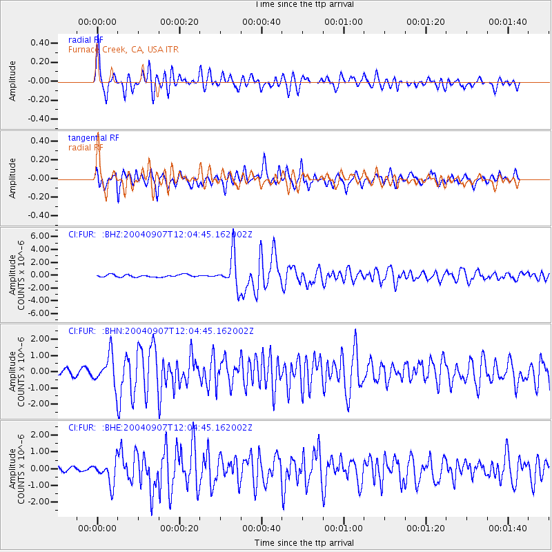
Signal To Noise
| Channel | StoN | STA | LTA |
| CI:FUR: :BHN:20040907T12:04:45.162002Z | 4.5023303 | 9.795139E-7 | 2.1755709E-7 |
| CI:FUR: :BHE:20040907T12:04:45.162002Z | 4.6496153 | 7.183246E-7 | 1.544912E-7 |
| CI:FUR: :BHZ:20040907T12:04:45.162002Z | 14.172877 | 2.6599414E-6 | 1.8767828E-7 |
| Arrivals |
| Ps | 4.5 SECOND |
| PpPs | 13 SECOND |
| PsPs/PpSs | 17 SECOND |


