You are here: Home > Network List > JP - Japan Meteorological Agency Seismic Network Stations List
> Station JKA Kamikawa Asahi > Earthquake Result Viewer
JKA Kamikawa Asahi - Earthquake Result Viewer
| Earthquake location: |
Banda Sea |
| Earthquake latitude/longitude: |
-7.3/123.4 |
| Earthquake time(UTC): |
2016/12/05 (340) 01:13:04 GMT |
| Earthquake Depth: |
526 km |
| Earthquake Magnitude: |
6.3 Mww |
| Earthquake Catalog/Contributor: |
NEIC PDE/us |
|
| Network: |
JP Japan Meteorological Agency Seismic Network |
| Station: |
JKA Kamikawa Asahi |
| Lat/Lon: |
41.12 N/142.59 E |
| Elevation: |
220 m |
|
| Distance: |
51.3 deg |
| Az: |
18.569 deg |
| Baz: |
204.715 deg |
| Ray Param: |
0.06516566 |
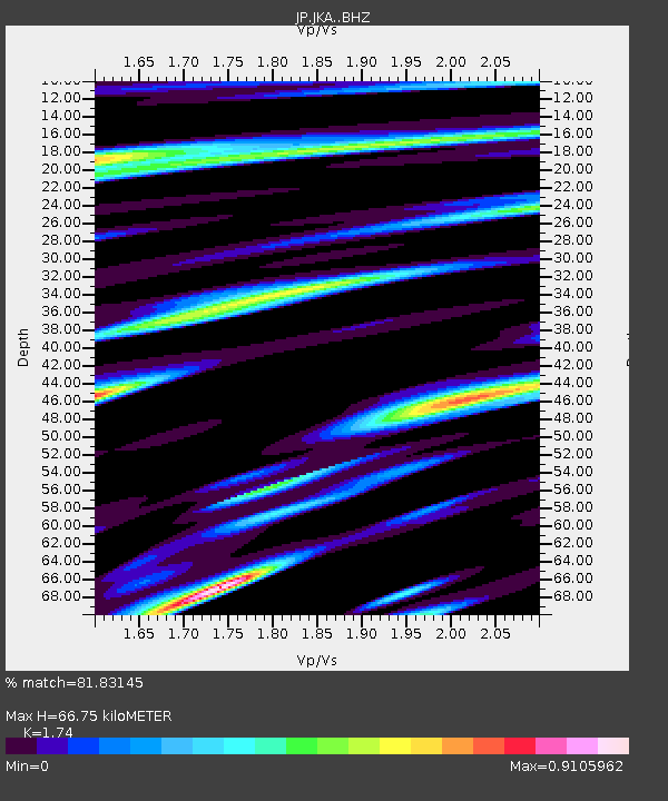
| Estimated Moho Depth: |
66.75 km |
| Estimated Crust Vp/Vs: |
1.74 |
| Assumed Crust Vp: |
6.183 km/s |
| Estimated Crust Vs: |
3.553 km/s |
| Estimated Crust Poisson's Ratio: |
0.25 |
|
| Radial Match: |
81.83145 % |
| Radial Bump: |
400 |
| Transverse Match: |
86.681274 % |
| Transverse Bump: |
400 |
| SOD ConfigId: |
11737051 |
| Insert Time: |
2019-04-26 05:21:05.351 +0000 |
| GWidth: |
2.5 |
| Max Bumps: |
400 |
| Tol: |
0.001 |
|

Signal To Noise
| Channel | StoN | STA | LTA |
| JP:JKA: :BHZ:20161205T01:21:09.149989Z | 0.41095117 | 7.7412444E-8 | 1.8837383E-7 |
| JP:JKA: :BHN:20161205T01:21:09.149989Z | 0.6093166 | 1.3932579E-7 | 2.286591E-7 |
| JP:JKA: :BHE:20161205T01:21:09.149989Z | 2.038391 | 2.4372008E-7 | 1.1956492E-7 |
| Arrivals |
| Ps | 8.4 SECOND |
| PpPs | 28 SECOND |
| PsPs/PpSs | 37 SECOND |


