You are here: Home > Network List > CI - Caltech Regional Seismic Network Stations List
> Station FUR Furnace Creek, CA, USA > Earthquake Result Viewer
FUR Furnace Creek, CA, USA - Earthquake Result Viewer
| Earthquake location: |
Near S. Coast Of Honshu, Japan |
| Earthquake latitude/longitude: |
33.2/137.2 |
| Earthquake time(UTC): |
2004/09/06 (250) 23:29:35 GMT |
| Earthquake Depth: |
10 km |
| Earthquake Magnitude: |
6.4 MB, 6.3 MS, 6.7 MW, 6.5 MW |
| Earthquake Catalog/Contributor: |
WHDF/NEIC |
|
| Network: |
CI Caltech Regional Seismic Network |
| Station: |
FUR Furnace Creek, CA, USA |
| Lat/Lon: |
36.47 N/116.86 W |
| Elevation: |
-37.0 m |
|
| Distance: |
82.1 deg |
| Az: |
51.502 deg |
| Baz: |
305.512 deg |
| Ray Param: |
0.04711552 |
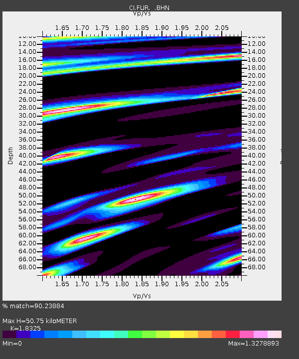
| Estimated Moho Depth: |
50.75 km |
| Estimated Crust Vp/Vs: |
1.83 |
| Assumed Crust Vp: |
6.279 km/s |
| Estimated Crust Vs: |
3.426 km/s |
| Estimated Crust Poisson's Ratio: |
0.29 |
|
| Radial Match: |
90.23884 % |
| Radial Bump: |
400 |
| Transverse Match: |
84.74732 % |
| Transverse Bump: |
400 |
| SOD ConfigId: |
2459 |
| Insert Time: |
2010-03-05 20:11:11.755 +0000 |
| GWidth: |
2.5 |
| Max Bumps: |
400 |
| Tol: |
0.001 |
|
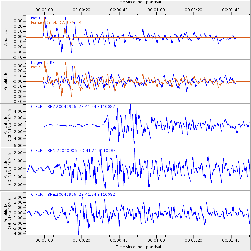
Signal To Noise
| Channel | StoN | STA | LTA |
| CI:FUR: :BHN:20040906T23:41:24.311008Z | 1.4963822 | 3.0702202E-7 | 2.0517619E-7 |
| CI:FUR: :BHE:20040906T23:41:24.311008Z | 2.6457276 | 6.383485E-7 | 2.4127522E-7 |
| CI:FUR: :BHZ:20040906T23:41:24.311008Z | 6.4104896 | 1.3196352E-6 | 2.058556E-7 |
| Arrivals |
| Ps | 6.9 SECOND |
| PpPs | 22 SECOND |
| PsPs/PpSs | 29 SECOND |


