You are here: Home > Network List > TA - USArray Transportable Network (new EarthScope stations) Stations List
> Station G21K Allakaket, AK, USA > Earthquake Result Viewer
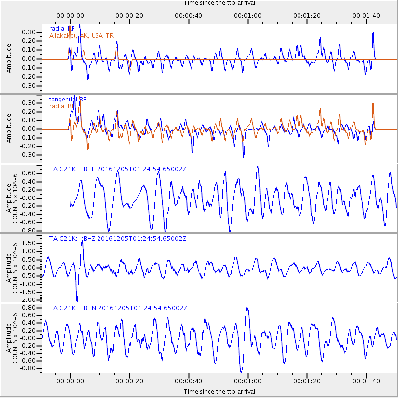
G21K Allakaket, AK, USA - Earthquake Result Viewer
*The percent match for this event was below the threshold and hence no stack was calculated.
| Earthquake location: |
Banda Sea |
| Earthquake latitude/longitude: |
-7.3/123.4 |
| Earthquake time(UTC): |
2016/12/05 (340) 01:13:04 GMT |
| Earthquake Depth: |
526 km |
| Earthquake Magnitude: |
6.3 Mww |
| Earthquake Catalog/Contributor: |
NEIC PDE/us |
|
| Network: |
TA USArray Transportable Network (new EarthScope stations) |
| Station: |
G21K Allakaket, AK, USA |
| Lat/Lon: |
66.52 N/153.51 W |
| Elevation: |
446 m |
|
| Distance: |
93.9 deg |
| Az: |
23.503 deg |
| Baz: |
260.791 deg |
| Ray Param: |
$rayparam |
*The percent match for this event was below the threshold and hence was not used in the summary stack. |
|
| Radial Match: |
55.62418 % |
| Radial Bump: |
400 |
| Transverse Match: |
61.356186 % |
| Transverse Bump: |
366 |
| SOD ConfigId: |
11737051 |
| Insert Time: |
2019-04-26 05:22:14.296 +0000 |
| GWidth: |
2.5 |
| Max Bumps: |
400 |
| Tol: |
0.001 |
|
Signal To Noise
| Channel | StoN | STA | LTA |
| TA:G21K: :BHZ:20161205T01:24:54.65002Z | 2.7332287 | 9.0059507E-7 | 3.2949862E-7 |
| TA:G21K: :BHN:20161205T01:24:54.65002Z | 0.9284741 | 2.5548408E-7 | 2.7516555E-7 |
| TA:G21K: :BHE:20161205T01:24:54.65002Z | 1.3688415 | 4.580769E-7 | 3.3464568E-7 |
| Arrivals |
| Ps | |
| PpPs | |
| PsPs/PpSs | |


