You are here: Home > Network List > CI - Caltech Regional Seismic Network Stations List
> Station FUR Furnace Creek, CA, USA > Earthquake Result Viewer
FUR Furnace Creek, CA, USA - Earthquake Result Viewer
| Earthquake location: |
Near Coast Of Nicaragua |
| Earthquake latitude/longitude: |
11.2/-86.2 |
| Earthquake time(UTC): |
2005/07/02 (183) 02:16:43 GMT |
| Earthquake Depth: |
27 km |
| Earthquake Magnitude: |
5.6 MB, 6.4 MS, 6.6 MW, 6.6 MW |
| Earthquake Catalog/Contributor: |
WHDF/NEIC |
|
| Network: |
CI Caltech Regional Seismic Network |
| Station: |
FUR Furnace Creek, CA, USA |
| Lat/Lon: |
36.47 N/116.86 W |
| Elevation: |
-37.0 m |
|
| Distance: |
37.4 deg |
| Az: |
317.325 deg |
| Baz: |
124.416 deg |
| Ray Param: |
0.07612793 |
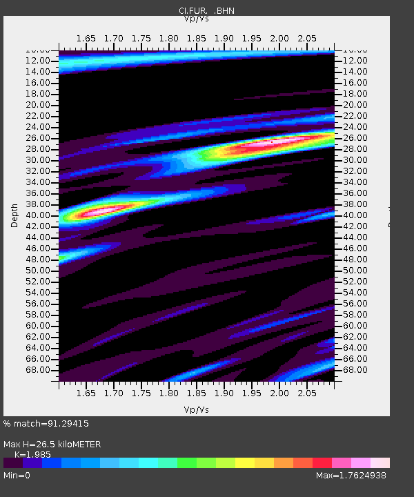
| Estimated Moho Depth: |
26.5 km |
| Estimated Crust Vp/Vs: |
1.99 |
| Assumed Crust Vp: |
6.279 km/s |
| Estimated Crust Vs: |
3.163 km/s |
| Estimated Crust Poisson's Ratio: |
0.33 |
|
| Radial Match: |
91.29415 % |
| Radial Bump: |
400 |
| Transverse Match: |
80.64638 % |
| Transverse Bump: |
400 |
| SOD ConfigId: |
2475 |
| Insert Time: |
2010-03-05 20:11:35.266 +0000 |
| GWidth: |
2.5 |
| Max Bumps: |
400 |
| Tol: |
0.001 |
|

Signal To Noise
| Channel | StoN | STA | LTA |
| CI:FUR: :BHN:20050702T02:23:23.437Z | 5.62663 | 8.41835E-7 | 1.496162E-7 |
| CI:FUR: :BHE:20050702T02:23:23.437Z | 10.097473 | 1.0580577E-6 | 1.0478441E-7 |
| CI:FUR: :BHZ:20050702T02:23:23.437Z | 19.086296 | 2.0566827E-6 | 1.07757025E-7 |
| Arrivals |
| Ps | 4.4 SECOND |
| PpPs | 12 SECOND |
| PsPs/PpSs | 16 SECOND |


