You are here: Home > Network List > CI - Caltech Regional Seismic Network Stations List
> Station FUR Furnace Creek, CA, USA > Earthquake Result Viewer
FUR Furnace Creek, CA, USA - Earthquake Result Viewer
| Earthquake location: |
Unimak Island Region, Alaska |
| Earthquake latitude/longitude: |
53.8/-164.1 |
| Earthquake time(UTC): |
2005/11/20 (324) 12:53:02 GMT |
| Earthquake Depth: |
30 km |
| Earthquake Magnitude: |
5.7 MB, 5.8 MS, 6.2 MW, 6.0 MW |
| Earthquake Catalog/Contributor: |
WHDF/NEIC |
|
| Network: |
CI Caltech Regional Seismic Network |
| Station: |
FUR Furnace Creek, CA, USA |
| Lat/Lon: |
36.47 N/116.86 W |
| Elevation: |
-37.0 m |
|
| Distance: |
36.8 deg |
| Az: |
98.672 deg |
| Baz: |
313.388 deg |
| Ray Param: |
0.07644773 |
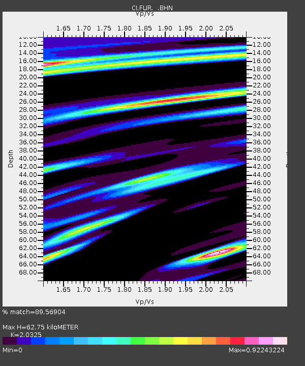
| Estimated Moho Depth: |
62.75 km |
| Estimated Crust Vp/Vs: |
2.03 |
| Assumed Crust Vp: |
6.279 km/s |
| Estimated Crust Vs: |
3.089 km/s |
| Estimated Crust Poisson's Ratio: |
0.34 |
|
| Radial Match: |
89.56904 % |
| Radial Bump: |
400 |
| Transverse Match: |
64.467735 % |
| Transverse Bump: |
400 |
| SOD ConfigId: |
2448 |
| Insert Time: |
2010-03-05 20:11:46.063 +0000 |
| GWidth: |
2.5 |
| Max Bumps: |
400 |
| Tol: |
0.001 |
|
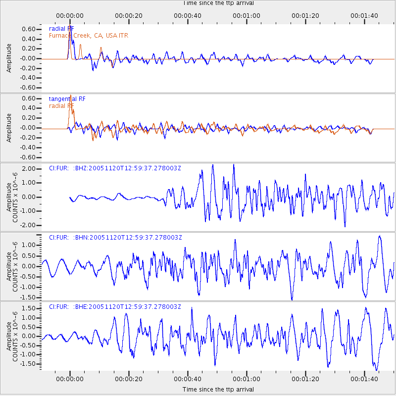
Signal To Noise
| Channel | StoN | STA | LTA |
| CI:FUR: :BHN:20051120T12:59:37.278003Z | 1.3398004 | 1.9468884E-7 | 1.4531183E-7 |
| CI:FUR: :BHE:20051120T12:59:37.278003Z | 1.3177706 | 1.4916473E-7 | 1.1319476E-7 |
| CI:FUR: :BHZ:20051120T12:59:37.278003Z | 2.623564 | 3.1486346E-7 | 1.2001364E-7 |
| Arrivals |
| Ps | 11 SECOND |
| PpPs | 29 SECOND |
| PsPs/PpSs | 39 SECOND |


