You are here: Home > Network List > OX - North-East Italy Seismic Network Stations List
> Station FUSE Fusea > Earthquake Result Viewer
FUSE Fusea - Earthquake Result Viewer
| Earthquake location: |
Windward Islands |
| Earthquake latitude/longitude: |
11.1/-60.9 |
| Earthquake time(UTC): |
2016/12/06 (341) 21:42:21 GMT |
| Earthquake Depth: |
35 km |
| Earthquake Magnitude: |
5.9 Mww |
| Earthquake Catalog/Contributor: |
NEIC PDE/us |
|
| Network: |
OX North-East Italy Seismic Network |
| Station: |
FUSE Fusea |
| Lat/Lon: |
46.41 N/13.00 E |
| Elevation: |
520 m |
|
| Distance: |
71.0 deg |
| Az: |
44.682 deg |
| Baz: |
266.088 deg |
| Ray Param: |
0.05457408 |
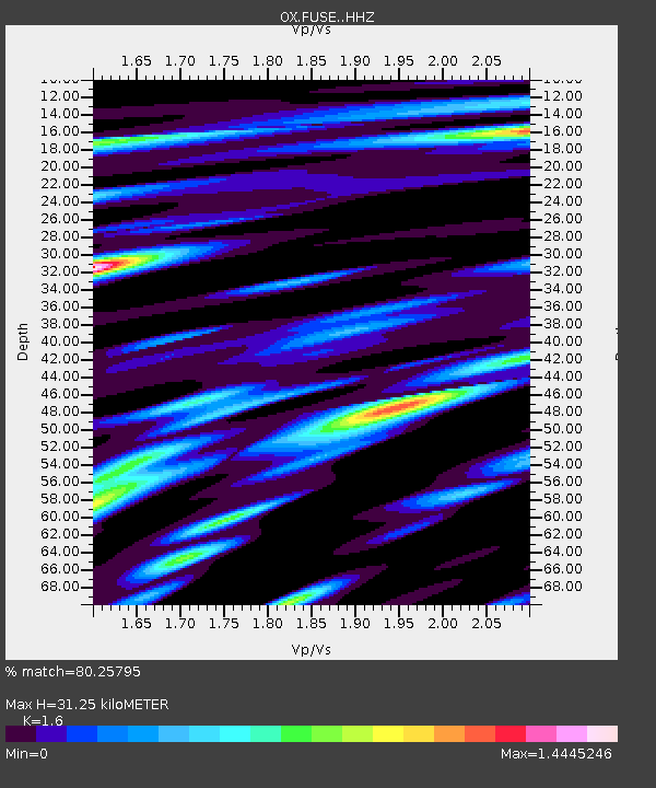
| Estimated Moho Depth: |
31.25 km |
| Estimated Crust Vp/Vs: |
1.60 |
| Assumed Crust Vp: |
6.35 km/s |
| Estimated Crust Vs: |
3.969 km/s |
| Estimated Crust Poisson's Ratio: |
0.18 |
|
| Radial Match: |
80.25795 % |
| Radial Bump: |
400 |
| Transverse Match: |
65.533264 % |
| Transverse Bump: |
400 |
| SOD ConfigId: |
11737051 |
| Insert Time: |
2019-04-26 05:30:51.538 +0000 |
| GWidth: |
2.5 |
| Max Bumps: |
400 |
| Tol: |
0.001 |
|

Signal To Noise
| Channel | StoN | STA | LTA |
| OX:FUSE: :HHZ:20161206T21:53:04.467971Z | 3.304363 | 2.3110918E-7 | 6.994061E-8 |
| OX:FUSE: :HHN:20161206T21:53:04.467971Z | 0.6799489 | 6.135556E-8 | 9.023554E-8 |
| OX:FUSE: :HHE:20161206T21:53:04.467971Z | 2.1704502 | 1.351942E-7 | 6.228854E-8 |
| Arrivals |
| Ps | 3.1 SECOND |
| PpPs | 12 SECOND |
| PsPs/PpSs | 15 SECOND |


