You are here: Home > Network List > TA - USArray Transportable Network (new EarthScope stations) Stations List
> Station 435B Jarrell, TX, USA > Earthquake Result Viewer
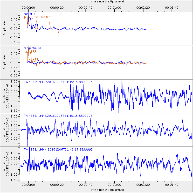
435B Jarrell, TX, USA - Earthquake Result Viewer
*The percent match for this event was below the threshold and hence no stack was calculated.
| Earthquake location: |
Windward Islands |
| Earthquake latitude/longitude: |
11.1/-60.9 |
| Earthquake time(UTC): |
2016/12/06 (341) 21:42:21 GMT |
| Earthquake Depth: |
35 km |
| Earthquake Magnitude: |
5.9 Mww |
| Earthquake Catalog/Contributor: |
NEIC PDE/us |
|
| Network: |
TA USArray Transportable Network (new EarthScope stations) |
| Station: |
435B Jarrell, TX, USA |
| Lat/Lon: |
30.78 N/97.58 W |
| Elevation: |
248 m |
|
| Distance: |
39.2 deg |
| Az: |
305.614 deg |
| Baz: |
111.985 deg |
| Ray Param: |
$rayparam |
*The percent match for this event was below the threshold and hence was not used in the summary stack. |
|
| Radial Match: |
74.53548 % |
| Radial Bump: |
399 |
| Transverse Match: |
61.186363 % |
| Transverse Bump: |
400 |
| SOD ConfigId: |
11737051 |
| Insert Time: |
2019-04-26 05:32:00.462 +0000 |
| GWidth: |
2.5 |
| Max Bumps: |
400 |
| Tol: |
0.001 |
|
Signal To Noise
| Channel | StoN | STA | LTA |
| TA:435B: :HHZ:20161206T21:49:15.889999Z | 6.7279625 | 9.960759E-7 | 1.4805015E-7 |
| TA:435B: :HHN:20161206T21:49:15.889999Z | 3.5224333 | 4.642683E-7 | 1.3180329E-7 |
| TA:435B: :HHE:20161206T21:49:15.889999Z | 2.7641492 | 6.625757E-7 | 2.397033E-7 |
| Arrivals |
| Ps | |
| PpPs | |
| PsPs/PpSs | |


