You are here: Home > Network List > TA - USArray Transportable Network (new EarthScope stations) Stations List
> Station D25K Kavik River, AK, USA > Earthquake Result Viewer
D25K Kavik River, AK, USA - Earthquake Result Viewer
*The percent match for this event was below the threshold and hence no stack was calculated.
| Earthquake location: |
Windward Islands |
| Earthquake latitude/longitude: |
11.1/-60.9 |
| Earthquake time(UTC): |
2016/12/06 (341) 21:42:21 GMT |
| Earthquake Depth: |
35 km |
| Earthquake Magnitude: |
5.9 Mww |
| Earthquake Catalog/Contributor: |
NEIC PDE/us |
|
| Network: |
TA USArray Transportable Network (new EarthScope stations) |
| Station: |
D25K Kavik River, AK, USA |
| Lat/Lon: |
69.32 N/146.38 W |
| Elevation: |
770 m |
|
| Distance: |
78.1 deg |
| Az: |
338.787 deg |
| Baz: |
90.276 deg |
| Ray Param: |
$rayparam |
*The percent match for this event was below the threshold and hence was not used in the summary stack. |
|
| Radial Match: |
66.02659 % |
| Radial Bump: |
400 |
| Transverse Match: |
68.78604 % |
| Transverse Bump: |
400 |
| SOD ConfigId: |
11737051 |
| Insert Time: |
2019-04-26 05:32:09.353 +0000 |
| GWidth: |
2.5 |
| Max Bumps: |
400 |
| Tol: |
0.001 |
|
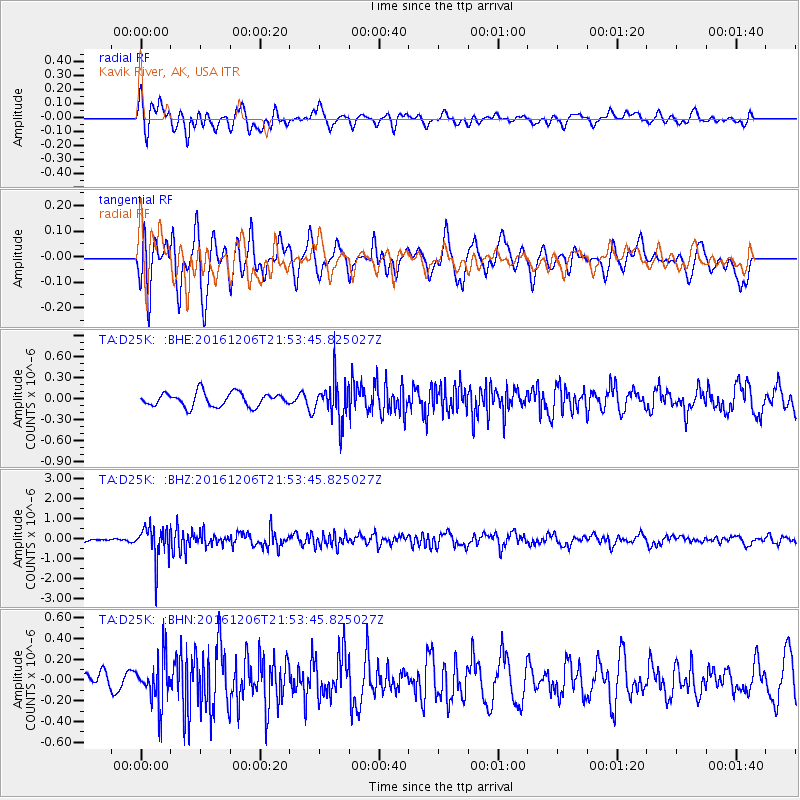
Signal To Noise
| Channel | StoN | STA | LTA |
| TA:D25K: :BHZ:20161206T21:53:45.825027Z | 9.382491 | 8.3641396E-7 | 8.9146255E-8 |
| TA:D25K: :BHN:20161206T21:53:45.825027Z | 2.3613946 | 2.1566957E-7 | 9.133144E-8 |
| TA:D25K: :BHE:20161206T21:53:45.825027Z | 2.9386187 | 2.9046402E-7 | 9.884372E-8 |
| Arrivals |
| Ps | |
| PpPs | |
| PsPs/PpSs | |


