You are here: Home > Network List > TA - USArray Transportable Network (new EarthScope stations) Stations List
> Station I23K Minto, Yukon-Koyukuk, AK, USA > Earthquake Result Viewer
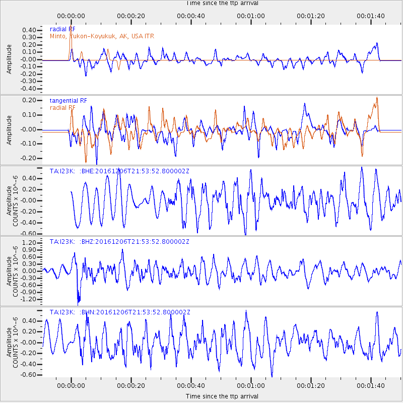
I23K Minto, Yukon-Koyukuk, AK, USA - Earthquake Result Viewer
*The percent match for this event was below the threshold and hence no stack was calculated.
| Earthquake location: |
Windward Islands |
| Earthquake latitude/longitude: |
11.1/-60.9 |
| Earthquake time(UTC): |
2016/12/06 (341) 21:42:21 GMT |
| Earthquake Depth: |
35 km |
| Earthquake Magnitude: |
5.9 Mww |
| Earthquake Catalog/Contributor: |
NEIC PDE/us |
|
| Network: |
TA USArray Transportable Network (new EarthScope stations) |
| Station: |
I23K Minto, Yukon-Koyukuk, AK, USA |
| Lat/Lon: |
65.15 N/149.36 W |
| Elevation: |
149 m |
|
| Distance: |
79.4 deg |
| Az: |
334.545 deg |
| Baz: |
86.697 deg |
| Ray Param: |
$rayparam |
*The percent match for this event was below the threshold and hence was not used in the summary stack. |
|
| Radial Match: |
45.0507 % |
| Radial Bump: |
400 |
| Transverse Match: |
44.767242 % |
| Transverse Bump: |
400 |
| SOD ConfigId: |
11737051 |
| Insert Time: |
2019-04-26 05:32:23.906 +0000 |
| GWidth: |
2.5 |
| Max Bumps: |
400 |
| Tol: |
0.001 |
|
Signal To Noise
| Channel | StoN | STA | LTA |
| TA:I23K: :BHZ:20161206T21:53:52.800002Z | 2.507572 | 5.85912E-7 | 2.3365712E-7 |
| TA:I23K: :BHN:20161206T21:53:52.800002Z | 0.6797928 | 1.7722535E-7 | 2.6070492E-7 |
| TA:I23K: :BHE:20161206T21:53:52.800002Z | 0.4450656 | 1.2289394E-7 | 2.7612543E-7 |
| Arrivals |
| Ps | |
| PpPs | |
| PsPs/PpSs | |


