You are here: Home > Network List > TA - USArray Transportable Network (new EarthScope stations) Stations List
> Station L44A Lake County Forest Preserve, Grayslake, IL, USA > Earthquake Result Viewer
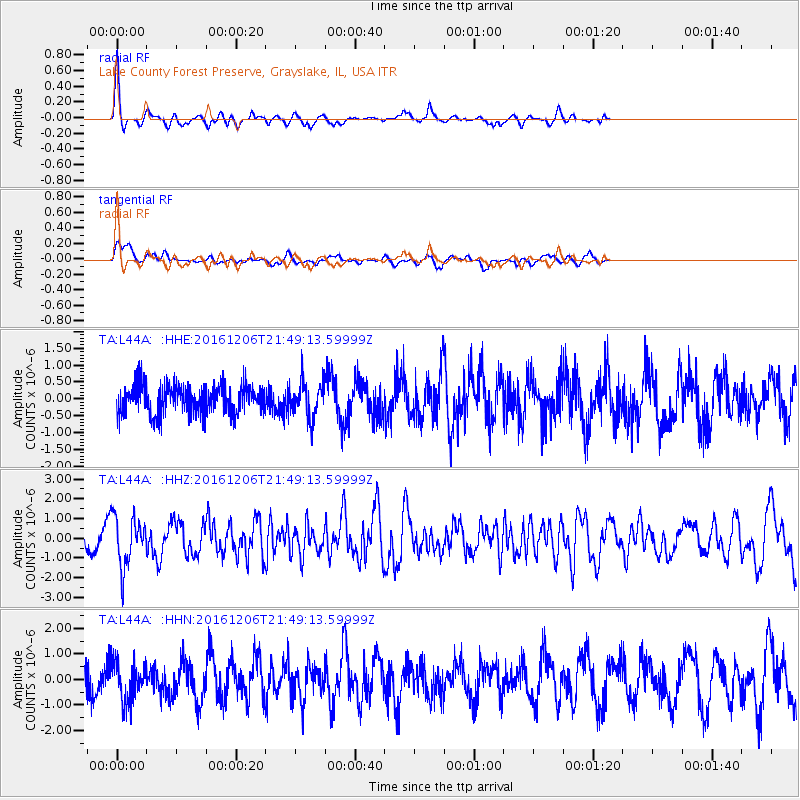
L44A Lake County Forest Preserve, Grayslake, IL, USA - Earthquake Result Viewer
*The percent match for this event was below the threshold and hence no stack was calculated.
| Earthquake location: |
Windward Islands |
| Earthquake latitude/longitude: |
11.1/-60.9 |
| Earthquake time(UTC): |
2016/12/06 (341) 21:42:21 GMT |
| Earthquake Depth: |
35 km |
| Earthquake Magnitude: |
5.9 Mww |
| Earthquake Catalog/Contributor: |
NEIC PDE/us |
|
| Network: |
TA USArray Transportable Network (new EarthScope stations) |
| Station: |
L44A Lake County Forest Preserve, Grayslake, IL, USA |
| Lat/Lon: |
42.18 N/87.91 W |
| Elevation: |
202 m |
|
| Distance: |
39.0 deg |
| Az: |
327.526 deg |
| Baz: |
134.84 deg |
| Ray Param: |
$rayparam |
*The percent match for this event was below the threshold and hence was not used in the summary stack. |
|
| Radial Match: |
72.745 % |
| Radial Bump: |
264 |
| Transverse Match: |
53.72157 % |
| Transverse Bump: |
350 |
| SOD ConfigId: |
11737051 |
| Insert Time: |
2019-04-26 05:32:35.115 +0000 |
| GWidth: |
2.5 |
| Max Bumps: |
400 |
| Tol: |
0.001 |
|
Signal To Noise
| Channel | StoN | STA | LTA |
| TA:L44A: :HHZ:20161206T21:49:13.59999Z | 2.9705257 | 1.2883849E-6 | 4.3372282E-7 |
| TA:L44A: :HHN:20161206T21:49:13.59999Z | 1.4002233 | 7.7525436E-7 | 5.536648E-7 |
| TA:L44A: :HHE:20161206T21:49:13.59999Z | 1.2371277 | 5.2549296E-7 | 4.247686E-7 |
| Arrivals |
| Ps | |
| PpPs | |
| PsPs/PpSs | |


