You are here: Home > Network List > TA - USArray Transportable Network (new EarthScope stations) Stations List
> Station M31M Drury Creek, Yukon, CA > Earthquake Result Viewer
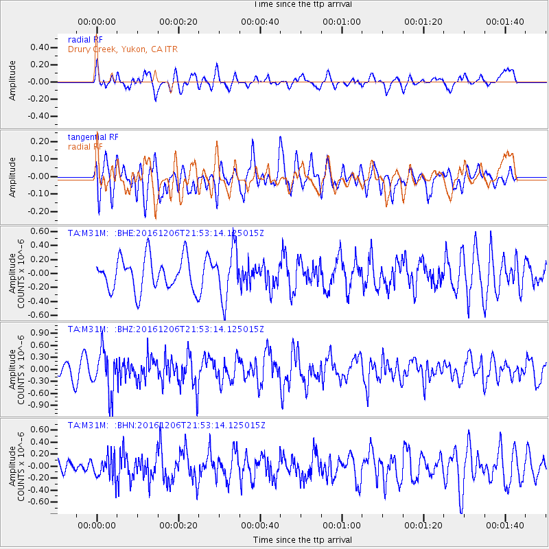
M31M Drury Creek, Yukon, CA - Earthquake Result Viewer
*The percent match for this event was below the threshold and hence no stack was calculated.
| Earthquake location: |
Windward Islands |
| Earthquake latitude/longitude: |
11.1/-60.9 |
| Earthquake time(UTC): |
2016/12/06 (341) 21:42:21 GMT |
| Earthquake Depth: |
35 km |
| Earthquake Magnitude: |
5.9 Mww |
| Earthquake Catalog/Contributor: |
NEIC PDE/us |
|
| Network: |
TA USArray Transportable Network (new EarthScope stations) |
| Station: |
M31M Drury Creek, Yukon, CA |
| Lat/Lon: |
62.20 N/134.39 W |
| Elevation: |
639 m |
|
| Distance: |
72.6 deg |
| Az: |
331.897 deg |
| Baz: |
99.473 deg |
| Ray Param: |
$rayparam |
*The percent match for this event was below the threshold and hence was not used in the summary stack. |
|
| Radial Match: |
58.068783 % |
| Radial Bump: |
400 |
| Transverse Match: |
53.182423 % |
| Transverse Bump: |
400 |
| SOD ConfigId: |
11737051 |
| Insert Time: |
2019-04-26 05:32:40.451 +0000 |
| GWidth: |
2.5 |
| Max Bumps: |
400 |
| Tol: |
0.001 |
|
Signal To Noise
| Channel | StoN | STA | LTA |
| TA:M31M: :BHZ:20161206T21:53:14.125015Z | 2.531513 | 5.398357E-7 | 2.1324628E-7 |
| TA:M31M: :BHN:20161206T21:53:14.125015Z | 0.7869888 | 1.84225E-7 | 2.3408846E-7 |
| TA:M31M: :BHE:20161206T21:53:14.125015Z | 1.5689954 | 3.6192134E-7 | 2.3067076E-7 |
| Arrivals |
| Ps | |
| PpPs | |
| PsPs/PpSs | |


