You are here: Home > Network List > AV - Alaska Volcano Observatory Stations List
> Station MAPS Pakushin Southeast, Makushin Volcano, Alaska > Earthquake Result Viewer
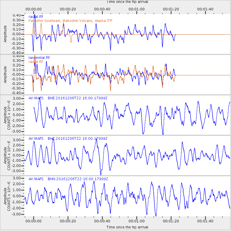
MAPS Pakushin Southeast, Makushin Volcano, Alaska - Earthquake Result Viewer
*The percent match for this event was below the threshold and hence no stack was calculated.
| Earthquake location: |
Northern Sumatra, Indonesia |
| Earthquake latitude/longitude: |
5.3/96.1 |
| Earthquake time(UTC): |
2016/12/06 (341) 22:03:32 GMT |
| Earthquake Depth: |
8.2 km |
| Earthquake Magnitude: |
6.5 Mww |
| Earthquake Catalog/Contributor: |
NEIC PDE/us |
|
| Network: |
AV Alaska Volcano Observatory |
| Station: |
MAPS Pakushin Southeast, Makushin Volcano, Alaska |
| Lat/Lon: |
53.81 N/166.94 W |
| Elevation: |
333 m |
|
| Distance: |
89.9 deg |
| Az: |
36.066 deg |
| Baz: |
278.7 deg |
| Ray Param: |
$rayparam |
*The percent match for this event was below the threshold and hence was not used in the summary stack. |
|
| Radial Match: |
66.82908 % |
| Radial Bump: |
400 |
| Transverse Match: |
68.13184 % |
| Transverse Bump: |
376 |
| SOD ConfigId: |
11737051 |
| Insert Time: |
2019-04-26 05:36:37.856 +0000 |
| GWidth: |
2.5 |
| Max Bumps: |
400 |
| Tol: |
0.001 |
|
Signal To Noise
| Channel | StoN | STA | LTA |
| AV:MAPS: :BHZ:20161206T22:16:00.17999Z | 2.162524 | 1.7196725E-6 | 7.952155E-7 |
| AV:MAPS: :BHN:20161206T22:16:00.17999Z | 0.59056664 | 7.084246E-7 | 1.1995675E-6 |
| AV:MAPS: :BHE:20161206T22:16:00.17999Z | 0.6891985 | 7.305191E-7 | 1.0599546E-6 |
| Arrivals |
| Ps | |
| PpPs | |
| PsPs/PpSs | |


