You are here: Home > Network List > CB - China National Seismic Network Stations List
> Station HEH Heihe,Heilongjiang Province > Earthquake Result Viewer
HEH Heihe,Heilongjiang Province - Earthquake Result Viewer
| Earthquake location: |
Northern Sumatra, Indonesia |
| Earthquake latitude/longitude: |
5.3/96.1 |
| Earthquake time(UTC): |
2016/12/06 (341) 22:03:32 GMT |
| Earthquake Depth: |
8.2 km |
| Earthquake Magnitude: |
6.5 Mww |
| Earthquake Catalog/Contributor: |
NEIC PDE/us |
|
| Network: |
CB China National Seismic Network |
| Station: |
HEH Heihe,Heilongjiang Province |
| Lat/Lon: |
50.25 N/127.41 E |
| Elevation: |
165 m |
|
| Distance: |
52.0 deg |
| Az: |
25.057 deg |
| Baz: |
221.07 deg |
| Ray Param: |
0.067078516 |
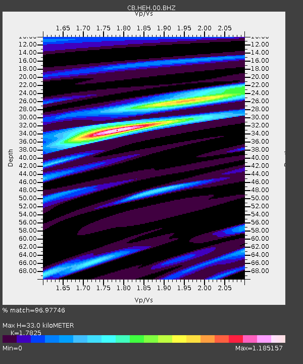
| Estimated Moho Depth: |
33.0 km |
| Estimated Crust Vp/Vs: |
1.78 |
| Assumed Crust Vp: |
6.419 km/s |
| Estimated Crust Vs: |
3.601 km/s |
| Estimated Crust Poisson's Ratio: |
0.27 |
|
| Radial Match: |
96.97746 % |
| Radial Bump: |
308 |
| Transverse Match: |
84.745605 % |
| Transverse Bump: |
400 |
| SOD ConfigId: |
11737051 |
| Insert Time: |
2019-04-26 05:36:46.644 +0000 |
| GWidth: |
2.5 |
| Max Bumps: |
400 |
| Tol: |
0.001 |
|
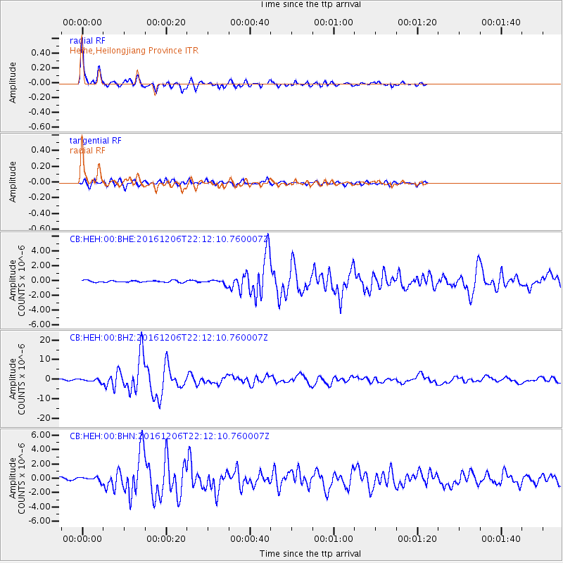
Signal To Noise
| Channel | StoN | STA | LTA |
| CB:HEH:00:BHZ:20161206T22:12:10.760007Z | 4.234421 | 8.017806E-7 | 1.8934834E-7 |
| CB:HEH:00:BHN:20161206T22:12:10.760007Z | 1.0676253 | 3.0155329E-7 | 2.824524E-7 |
| CB:HEH:00:BHE:20161206T22:12:10.760007Z | 2.8470235 | 3.2602412E-7 | 1.1451403E-7 |
| Arrivals |
| Ps | 4.3 SECOND |
| PpPs | 14 SECOND |
| PsPs/PpSs | 18 SECOND |


