You are here: Home > Network List > AV - Alaska Volcano Observatory Stations List
> Station SPCR Ckakachatna River, Mount Spurr, Alaska > Earthquake Result Viewer
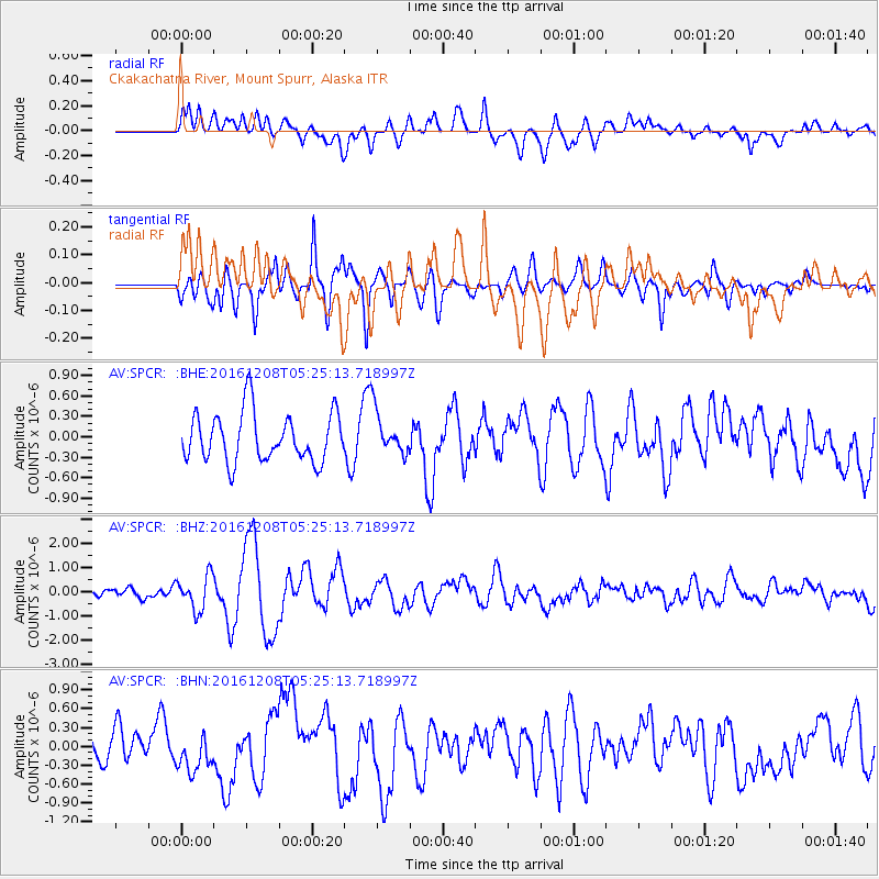
SPCR Ckakachatna River, Mount Spurr, Alaska - Earthquake Result Viewer
*The percent match for this event was below the threshold and hence no stack was calculated.
| Earthquake location: |
Northern Xinjiang, China |
| Earthquake latitude/longitude: |
43.8/86.3 |
| Earthquake time(UTC): |
2016/12/08 (343) 05:15:04 GMT |
| Earthquake Depth: |
14 km |
| Earthquake Magnitude: |
5.9 Mwp |
| Earthquake Catalog/Contributor: |
NEIC PDE/us |
|
| Network: |
AV Alaska Volcano Observatory |
| Station: |
SPCR Ckakachatna River, Mount Spurr, Alaska |
| Lat/Lon: |
61.20 N/152.21 W |
| Elevation: |
984 m |
|
| Distance: |
65.1 deg |
| Az: |
27.074 deg |
| Baz: |
317.126 deg |
| Ray Param: |
$rayparam |
*The percent match for this event was below the threshold and hence was not used in the summary stack. |
|
| Radial Match: |
57.299877 % |
| Radial Bump: |
400 |
| Transverse Match: |
56.39793 % |
| Transverse Bump: |
400 |
| SOD ConfigId: |
11737051 |
| Insert Time: |
2019-04-26 05:41:33.573 +0000 |
| GWidth: |
2.5 |
| Max Bumps: |
400 |
| Tol: |
0.001 |
|
Signal To Noise
| Channel | StoN | STA | LTA |
| AV:SPCR: :BHZ:20161208T05:25:13.718997Z | 3.3332632 | 7.0712144E-7 | 2.121409E-7 |
| AV:SPCR: :BHN:20161208T05:25:13.718997Z | 1.1858035 | 3.0027007E-7 | 2.5322075E-7 |
| AV:SPCR: :BHE:20161208T05:25:13.718997Z | 0.84026 | 3.001637E-7 | 3.5722715E-7 |
| Arrivals |
| Ps | |
| PpPs | |
| PsPs/PpSs | |


