You are here: Home > Network List > CI - Caltech Regional Seismic Network Stations List
> Station FUR Furnace Creek, CA, USA > Earthquake Result Viewer
FUR Furnace Creek, CA, USA - Earthquake Result Viewer
| Earthquake location: |
Kuril Islands |
| Earthquake latitude/longitude: |
46.6/153.3 |
| Earthquake time(UTC): |
2006/11/15 (319) 11:14:13 GMT |
| Earthquake Depth: |
10 km |
| Earthquake Magnitude: |
6.5 MB, 7.8 MS, 8.3 MW, 7.9 MW |
| Earthquake Catalog/Contributor: |
WHDF/NEIC |
|
| Network: |
CI Caltech Regional Seismic Network |
| Station: |
FUR Furnace Creek, CA, USA |
| Lat/Lon: |
36.47 N/116.86 W |
| Elevation: |
-37.0 m |
|
| Distance: |
64.5 deg |
| Az: |
63.223 deg |
| Baz: |
310.203 deg |
| Ray Param: |
0.058853414 |
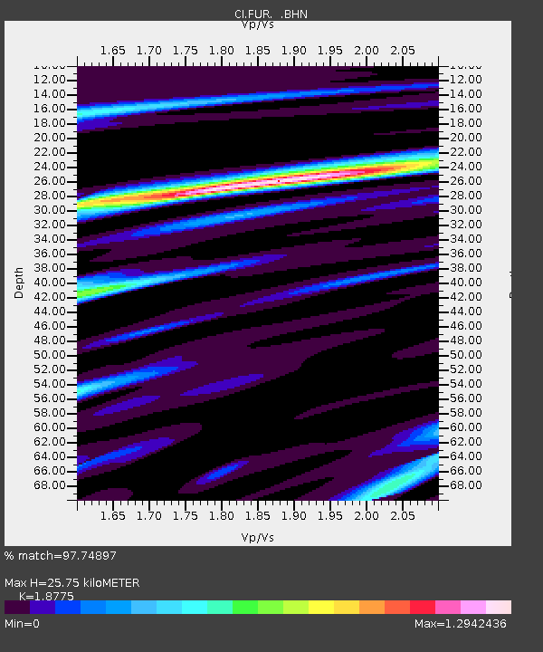
| Estimated Moho Depth: |
25.75 km |
| Estimated Crust Vp/Vs: |
1.88 |
| Assumed Crust Vp: |
6.279 km/s |
| Estimated Crust Vs: |
3.344 km/s |
| Estimated Crust Poisson's Ratio: |
0.30 |
|
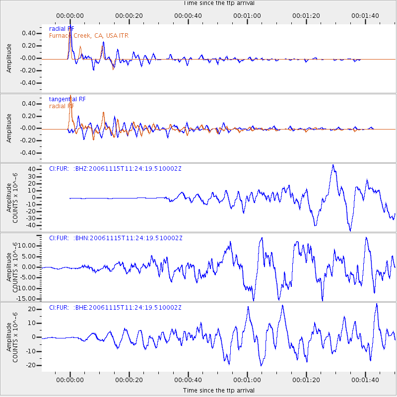
| Radial Match: |
97.74897 % |
| Radial Bump: |
400 |
| Transverse Match: |
85.228645 % |
| Transverse Bump: |
400 |
| SOD ConfigId: |
2564 |
| Insert Time: |
2010-03-05 20:15:09.174 +0000 |
| GWidth: |
2.5 |
| Max Bumps: |
400 |
| Tol: |
0.001 |
|
Signal To Noise
| Channel | StoN | STA | LTA |
| CI:FUR: :BHN:20061115T11:24:19.510002Z | 1.2330313 | 3.5678815E-7 | 2.8935855E-7 |
| CI:FUR: :BHE:20061115T11:24:19.510002Z | 3.5977008 | 8.4478467E-7 | 2.3481236E-7 |
| CI:FUR: :BHZ:20061115T11:24:19.510002Z | 6.625154 | 1.8787102E-6 | 2.8357232E-7 |
| Arrivals |
| Ps | 3.7 SECOND |
| PpPs | 11 SECOND |
| PsPs/PpSs | 15 SECOND |


