You are here: Home > Network List > TA - USArray Transportable Network (new EarthScope stations) Stations List
> Station C24K Franklin Bluffs, AK, USA > Earthquake Result Viewer
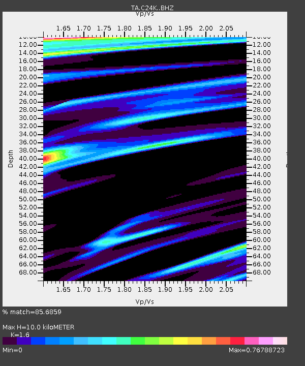
C24K Franklin Bluffs, AK, USA - Earthquake Result Viewer
| Earthquake location: |
Northern Xinjiang, China |
| Earthquake latitude/longitude: |
43.8/86.3 |
| Earthquake time(UTC): |
2016/12/08 (343) 05:15:04 GMT |
| Earthquake Depth: |
14 km |
| Earthquake Magnitude: |
5.9 Mwp |
| Earthquake Catalog/Contributor: |
NEIC PDE/us |
|
| Network: |
TA USArray Transportable Network (new EarthScope stations) |
| Station: |
C24K Franklin Bluffs, AK, USA |
| Lat/Lon: |
69.72 N/148.70 W |
| Elevation: |
115 m |
|
| Distance: |
59.9 deg |
| Az: |
19.282 deg |
| Baz: |
316.717 deg |
| Ray Param: |
0.06189279 |
| Estimated Moho Depth: |
10.0 km |
| Estimated Crust Vp/Vs: |
1.60 |
| Assumed Crust Vp: |
6.316 km/s |
| Estimated Crust Vs: |
3.948 km/s |
| Estimated Crust Poisson's Ratio: |
0.18 |
|
| Radial Match: |
85.6859 % |
| Radial Bump: |
400 |
| Transverse Match: |
71.10499 % |
| Transverse Bump: |
400 |
| SOD ConfigId: |
11737051 |
| Insert Time: |
2019-04-26 05:46:19.422 +0000 |
| GWidth: |
2.5 |
| Max Bumps: |
400 |
| Tol: |
0.001 |
|

Signal To Noise
| Channel | StoN | STA | LTA |
| TA:C24K: :BHZ:20161208T05:24:38.67499Z | 4.64795 | 1.1064081E-6 | 2.3804218E-7 |
| TA:C24K: :BHN:20161208T05:24:38.67499Z | 0.67232317 | 2.0806131E-7 | 3.094662E-7 |
| TA:C24K: :BHE:20161208T05:24:38.67499Z | 0.7761398 | 2.8991914E-7 | 3.7353985E-7 |
| Arrivals |
| Ps | 1.0 SECOND |
| PpPs | 3.9 SECOND |
| PsPs/PpSs | 4.9 SECOND |


