You are here: Home > Network List > TA - USArray Transportable Network (new EarthScope stations) Stations List
> Station F22K John River, AK, USA > Earthquake Result Viewer
F22K John River, AK, USA - Earthquake Result Viewer
| Earthquake location: |
Northern Xinjiang, China |
| Earthquake latitude/longitude: |
43.8/86.3 |
| Earthquake time(UTC): |
2016/12/08 (343) 05:15:04 GMT |
| Earthquake Depth: |
14 km |
| Earthquake Magnitude: |
5.9 Mwp |
| Earthquake Catalog/Contributor: |
NEIC PDE/us |
|
| Network: |
TA USArray Transportable Network (new EarthScope stations) |
| Station: |
F22K John River, AK, USA |
| Lat/Lon: |
67.51 N/152.18 W |
| Elevation: |
546 m |
|
| Distance: |
60.6 deg |
| Az: |
22.121 deg |
| Baz: |
314.89 deg |
| Ray Param: |
0.06143011 |
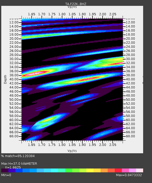
| Estimated Moho Depth: |
37.0 km |
| Estimated Crust Vp/Vs: |
1.66 |
| Assumed Crust Vp: |
6.455 km/s |
| Estimated Crust Vs: |
3.883 km/s |
| Estimated Crust Poisson's Ratio: |
0.22 |
|
| Radial Match: |
85.120384 % |
| Radial Bump: |
400 |
| Transverse Match: |
66.269226 % |
| Transverse Bump: |
400 |
| SOD ConfigId: |
11737051 |
| Insert Time: |
2019-04-26 05:46:30.119 +0000 |
| GWidth: |
2.5 |
| Max Bumps: |
400 |
| Tol: |
0.001 |
|

Signal To Noise
| Channel | StoN | STA | LTA |
| TA:F22K: :BHZ:20161208T05:24:43.474978Z | 3.9700308 | 7.288139E-7 | 1.835789E-7 |
| TA:F22K: :BHN:20161208T05:24:43.474978Z | 1.6634886 | 2.0143833E-7 | 1.2109389E-7 |
| TA:F22K: :BHE:20161208T05:24:43.474978Z | 1.5272707 | 1.513673E-7 | 9.910968E-8 |
| Arrivals |
| Ps | 4.0 SECOND |
| PpPs | 15 SECOND |
| PsPs/PpSs | 19 SECOND |


