You are here: Home > Network List > TA - USArray Transportable Network (new EarthScope stations) Stations List
> Station H24K Noodor Dome, AK, USA > Earthquake Result Viewer
H24K Noodor Dome, AK, USA - Earthquake Result Viewer
| Earthquake location: |
Northern Xinjiang, China |
| Earthquake latitude/longitude: |
43.8/86.3 |
| Earthquake time(UTC): |
2016/12/08 (343) 05:15:04 GMT |
| Earthquake Depth: |
14 km |
| Earthquake Magnitude: |
5.9 Mwp |
| Earthquake Catalog/Contributor: |
NEIC PDE/us |
|
| Network: |
TA USArray Transportable Network (new EarthScope stations) |
| Station: |
H24K Noodor Dome, AK, USA |
| Lat/Lon: |
65.84 N/147.88 W |
| Elevation: |
814 m |
|
| Distance: |
63.0 deg |
| Az: |
22.005 deg |
| Baz: |
318.781 deg |
| Ray Param: |
0.05986892 |
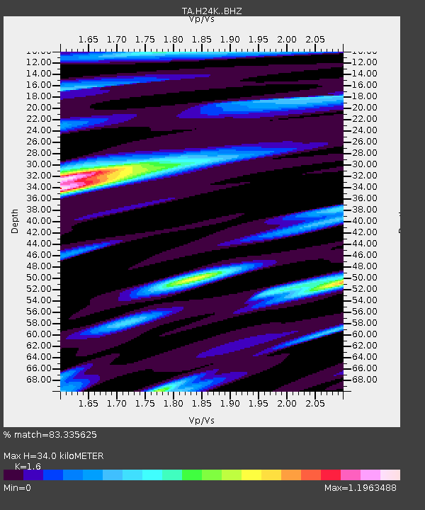
| Estimated Moho Depth: |
34.0 km |
| Estimated Crust Vp/Vs: |
1.60 |
| Assumed Crust Vp: |
6.566 km/s |
| Estimated Crust Vs: |
4.104 km/s |
| Estimated Crust Poisson's Ratio: |
0.18 |
|
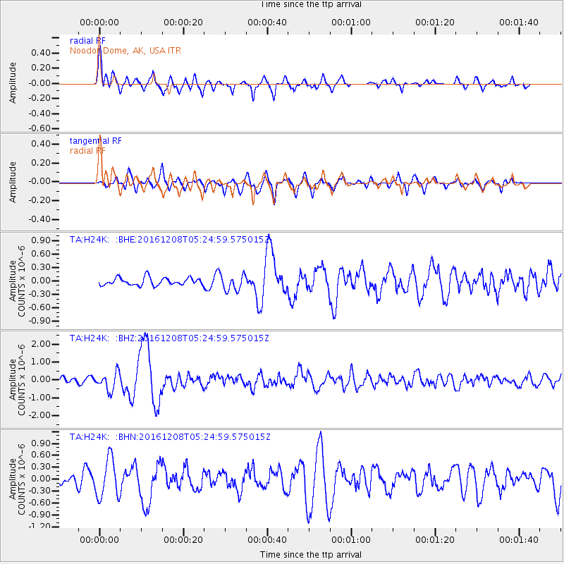
| Radial Match: |
83.335625 % |
| Radial Bump: |
400 |
| Transverse Match: |
74.157745 % |
| Transverse Bump: |
390 |
| SOD ConfigId: |
11737051 |
| Insert Time: |
2019-04-26 05:46:39.873 +0000 |
| GWidth: |
2.5 |
| Max Bumps: |
400 |
| Tol: |
0.001 |
|
Signal To Noise
| Channel | StoN | STA | LTA |
| TA:H24K: :BHZ:20161208T05:24:59.575015Z | 3.2214534 | 5.120667E-7 | 1.5895517E-7 |
| TA:H24K: :BHN:20161208T05:24:59.575015Z | 3.2217853 | 5.056385E-7 | 1.5694359E-7 |
| TA:H24K: :BHE:20161208T05:24:59.575015Z | 2.0765047 | 1.7336538E-7 | 8.348903E-8 |
| Arrivals |
| Ps | 3.3 SECOND |
| PpPs | 13 SECOND |
| PsPs/PpSs | 16 SECOND |


