You are here: Home > Network List > TA - USArray Transportable Network (new EarthScope stations) Stations List
> Station I23K Minto, Yukon-Koyukuk, AK, USA > Earthquake Result Viewer
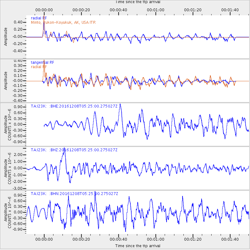
I23K Minto, Yukon-Koyukuk, AK, USA - Earthquake Result Viewer
*The percent match for this event was below the threshold and hence no stack was calculated.
| Earthquake location: |
Northern Xinjiang, China |
| Earthquake latitude/longitude: |
43.8/86.3 |
| Earthquake time(UTC): |
2016/12/08 (343) 05:15:04 GMT |
| Earthquake Depth: |
14 km |
| Earthquake Magnitude: |
5.9 Mwp |
| Earthquake Catalog/Contributor: |
NEIC PDE/us |
|
| Network: |
TA USArray Transportable Network (new EarthScope stations) |
| Station: |
I23K Minto, Yukon-Koyukuk, AK, USA |
| Lat/Lon: |
65.15 N/149.36 W |
| Elevation: |
149 m |
|
| Distance: |
63.1 deg |
| Az: |
23.04 deg |
| Baz: |
317.903 deg |
| Ray Param: |
$rayparam |
*The percent match for this event was below the threshold and hence was not used in the summary stack. |
|
| Radial Match: |
67.51827 % |
| Radial Bump: |
400 |
| Transverse Match: |
72.446754 % |
| Transverse Bump: |
400 |
| SOD ConfigId: |
11737051 |
| Insert Time: |
2019-04-26 05:46:44.075 +0000 |
| GWidth: |
2.5 |
| Max Bumps: |
400 |
| Tol: |
0.001 |
|
Signal To Noise
| Channel | StoN | STA | LTA |
| TA:I23K: :BHZ:20161208T05:25:00.275027Z | 5.7772017 | 6.671134E-7 | 1.1547345E-7 |
| TA:I23K: :BHN:20161208T05:25:00.275027Z | 1.7334737 | 3.091831E-7 | 1.7836041E-7 |
| TA:I23K: :BHE:20161208T05:25:00.275027Z | 2.5222273 | 3.3257325E-7 | 1.3185696E-7 |
| Arrivals |
| Ps | |
| PpPs | |
| PsPs/PpSs | |


