You are here: Home > Network List > TA - USArray Transportable Network (new EarthScope stations) Stations List
> Station J26L Joseph Creek, AK, USA > Earthquake Result Viewer
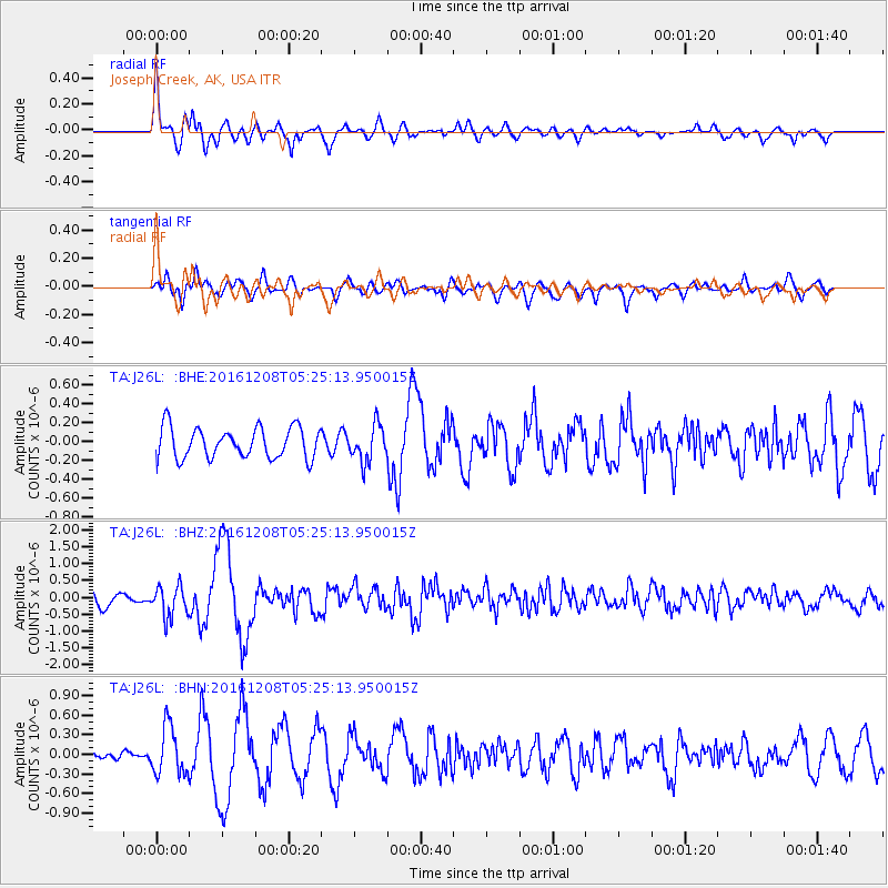
J26L Joseph Creek, AK, USA - Earthquake Result Viewer
*The percent match for this event was below the threshold and hence no stack was calculated.
| Earthquake location: |
Northern Xinjiang, China |
| Earthquake latitude/longitude: |
43.8/86.3 |
| Earthquake time(UTC): |
2016/12/08 (343) 05:15:04 GMT |
| Earthquake Depth: |
14 km |
| Earthquake Magnitude: |
5.9 Mwp |
| Earthquake Catalog/Contributor: |
NEIC PDE/us |
|
| Network: |
TA USArray Transportable Network (new EarthScope stations) |
| Station: |
J26L Joseph Creek, AK, USA |
| Lat/Lon: |
64.50 N/143.56 W |
| Elevation: |
1144 m |
|
| Distance: |
65.2 deg |
| Az: |
21.386 deg |
| Baz: |
322.422 deg |
| Ray Param: |
$rayparam |
*The percent match for this event was below the threshold and hence was not used in the summary stack. |
|
| Radial Match: |
66.31101 % |
| Radial Bump: |
400 |
| Transverse Match: |
66.61071 % |
| Transverse Bump: |
400 |
| SOD ConfigId: |
11737051 |
| Insert Time: |
2019-04-26 05:46:47.002 +0000 |
| GWidth: |
2.5 |
| Max Bumps: |
400 |
| Tol: |
0.001 |
|
Signal To Noise
| Channel | StoN | STA | LTA |
| TA:J26L: :BHZ:20161208T05:25:13.950015Z | 2.0725946 | 4.5966922E-7 | 2.2178443E-7 |
| TA:J26L: :BHN:20161208T05:25:13.950015Z | 3.5526135 | 3.697229E-7 | 1.0407068E-7 |
| TA:J26L: :BHE:20161208T05:25:13.950015Z | 1.180747 | 1.9050422E-7 | 1.6134211E-7 |
| Arrivals |
| Ps | |
| PpPs | |
| PsPs/PpSs | |


