You are here: Home > Network List > CI - Caltech Regional Seismic Network Stations List
> Station SDD SDD, Mission Viejo, CA, USA > Earthquake Result Viewer
SDD SDD, Mission Viejo, CA, USA - Earthquake Result Viewer
| Earthquake location: |
Bonin Islands, Japan Region |
| Earthquake latitude/longitude: |
28.9/139.6 |
| Earthquake time(UTC): |
2000/08/06 (219) 07:27:12 GMT |
| Earthquake Depth: |
395 km |
| Earthquake Magnitude: |
6.3 MB, 7.3 MW, 7.3 MW |
| Earthquake Catalog/Contributor: |
WHDF/NEIC |
|
| Network: |
CI Caltech Regional Seismic Network |
| Station: |
SDD SDD, Mission Viejo, CA, USA |
| Lat/Lon: |
33.55 N/117.66 W |
| Elevation: |
120 m |
|
| Distance: |
84.1 deg |
| Az: |
54.951 deg |
| Baz: |
300.689 deg |
| Ray Param: |
0.044634797 |
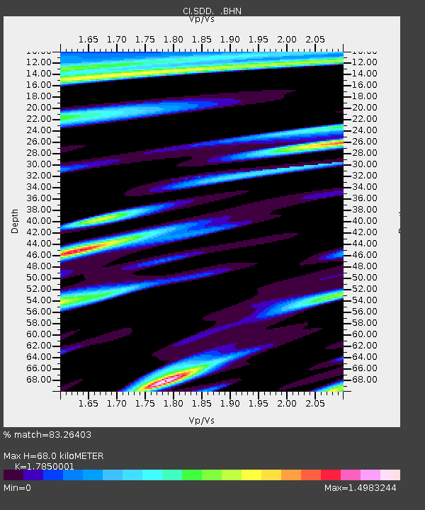
| Estimated Moho Depth: |
68.0 km |
| Estimated Crust Vp/Vs: |
1.79 |
| Assumed Crust Vp: |
6.264 km/s |
| Estimated Crust Vs: |
3.509 km/s |
| Estimated Crust Poisson's Ratio: |
0.27 |
|
| Radial Match: |
83.26403 % |
| Radial Bump: |
400 |
| Transverse Match: |
76.27989 % |
| Transverse Bump: |
400 |
| SOD ConfigId: |
3787 |
| Insert Time: |
2010-02-26 00:55:04.341 +0000 |
| GWidth: |
2.5 |
| Max Bumps: |
400 |
| Tol: |
0.001 |
|

Signal To Noise
| Channel | StoN | STA | LTA |
| CI:SDD: :BHN:20000806T07:38:29.637Z | 3.0644455 | 1.310101E-6 | 4.2751648E-7 |
| CI:SDD: :BHE:20000806T07:38:29.637Z | 2.2038918 | 1.0344806E-6 | 4.693881E-7 |
| CI:SDD: :BHZ:20000806T07:38:29.637Z | 13.629499 | 3.964091E-6 | 2.908464E-7 |
| Arrivals |
| Ps | 8.7 SECOND |
| PpPs | 30 SECOND |
| PsPs/PpSs | 38 SECOND |


