You are here: Home > Network List > CI - Caltech Regional Seismic Network Stations List
> Station FUR Furnace Creek, CA, USA > Earthquake Result Viewer
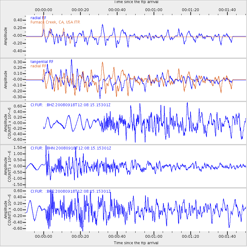
FUR Furnace Creek, CA, USA - Earthquake Result Viewer
*The percent match for this event was below the threshold and hence no stack was calculated.
| Earthquake location: |
Near East Coast Of Kamchatka |
| Earthquake latitude/longitude: |
51.9/158.4 |
| Earthquake time(UTC): |
2008/09/18 (262) 11:58:50 GMT |
| Earthquake Depth: |
67 km |
| Earthquake Magnitude: |
5.7 MB, 5.9 MW, 5.8 MW |
| Earthquake Catalog/Contributor: |
WHDF/NEIC |
|
| Network: |
CI Caltech Regional Seismic Network |
| Station: |
FUR Furnace Creek, CA, USA |
| Lat/Lon: |
36.47 N/116.86 W |
| Elevation: |
-37.0 m |
|
| Distance: |
59.3 deg |
| Az: |
68.971 deg |
| Baz: |
314.182 deg |
| Ray Param: |
$rayparam |
*The percent match for this event was below the threshold and hence was not used in the summary stack. |
|
| Radial Match: |
58.22887 % |
| Radial Bump: |
400 |
| Transverse Match: |
71.59104 % |
| Transverse Bump: |
400 |
| SOD ConfigId: |
2560 |
| Insert Time: |
2010-03-05 20:16:21.800 +0000 |
| GWidth: |
2.5 |
| Max Bumps: |
400 |
| Tol: |
0.001 |
|
Signal To Noise
| Channel | StoN | STA | LTA |
| CI:FUR: :BHN:20080918T12:08:15.15301Z | 3.7848806 | 5.708612E-7 | 1.5082672E-7 |
| CI:FUR: :BHE:20080918T12:08:15.15301Z | 1.1480281 | 2.4559534E-7 | 2.1392798E-7 |
| CI:FUR: :BHZ:20080918T12:08:15.15301Z | 0.99581826 | 1.5229313E-7 | 1.5293264E-7 |
| Arrivals |
| Ps | |
| PpPs | |
| PsPs/PpSs | |


