You are here: Home > Network List > CI - Caltech Regional Seismic Network Stations List
> Station FUR Furnace Creek, CA, USA > Earthquake Result Viewer
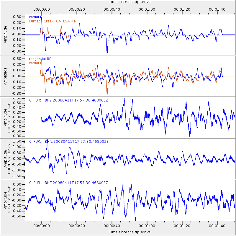
FUR Furnace Creek, CA, USA - Earthquake Result Viewer
*The percent match for this event was below the threshold and hence no stack was calculated.
| Earthquake location: |
Loyalty Islands |
| Earthquake latitude/longitude: |
-20.4/168.8 |
| Earthquake time(UTC): |
2008/04/11 (102) 17:45:05 GMT |
| Earthquake Depth: |
35 km |
| Earthquake Magnitude: |
5.7 MB, 5.9 MS, 6.0 MW, 6.0 MW |
| Earthquake Catalog/Contributor: |
WHDF/NEIC |
|
| Network: |
CI Caltech Regional Seismic Network |
| Station: |
FUR Furnace Creek, CA, USA |
| Lat/Lon: |
36.47 N/116.86 W |
| Elevation: |
-37.0 m |
|
| Distance: |
90.0 deg |
| Az: |
50.905 deg |
| Baz: |
244.569 deg |
| Ray Param: |
$rayparam |
*The percent match for this event was below the threshold and hence was not used in the summary stack. |
|
| Radial Match: |
66.7235 % |
| Radial Bump: |
400 |
| Transverse Match: |
61.26947 % |
| Transverse Bump: |
400 |
| SOD ConfigId: |
2504 |
| Insert Time: |
2010-03-05 20:16:42.168 +0000 |
| GWidth: |
2.5 |
| Max Bumps: |
400 |
| Tol: |
0.001 |
|
Signal To Noise
| Channel | StoN | STA | LTA |
| CI:FUR: :BHN:20080411T17:57:30.468003Z | 5.4862022 | 6.448573E-7 | 1.1754166E-7 |
| CI:FUR: :BHE:20080411T17:57:30.468003Z | 0.845508 | 1.2849391E-7 | 1.5197244E-7 |
| CI:FUR: :BHZ:20080411T17:57:30.468003Z | 2.1235704 | 2.5345835E-7 | 1.1935481E-7 |
| Arrivals |
| Ps | |
| PpPs | |
| PsPs/PpSs | |


