You are here: Home > Network List > CI - Caltech Regional Seismic Network Stations List
> Station FUR Furnace Creek, CA, USA > Earthquake Result Viewer
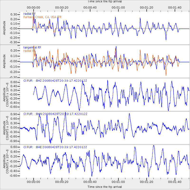
FUR Furnace Creek, CA, USA - Earthquake Result Viewer
*The percent match for this event was below the threshold and hence no stack was calculated.
| Earthquake location: |
Loyalty Islands |
| Earthquake latitude/longitude: |
-20.2/168.8 |
| Earthquake time(UTC): |
2008/04/28 (119) 20:26:53 GMT |
| Earthquake Depth: |
35 km |
| Earthquake Magnitude: |
5.8 MB, 5.7 MS, 6.1 MW, 6.0 MW |
| Earthquake Catalog/Contributor: |
WHDF/NEIC |
|
| Network: |
CI Caltech Regional Seismic Network |
| Station: |
FUR Furnace Creek, CA, USA |
| Lat/Lon: |
36.47 N/116.86 W |
| Elevation: |
-37.0 m |
|
| Distance: |
89.9 deg |
| Az: |
50.903 deg |
| Baz: |
244.694 deg |
| Ray Param: |
$rayparam |
*The percent match for this event was below the threshold and hence was not used in the summary stack. |
|
| Radial Match: |
71.71064 % |
| Radial Bump: |
400 |
| Transverse Match: |
55.998352 % |
| Transverse Bump: |
400 |
| SOD ConfigId: |
2504 |
| Insert Time: |
2010-03-05 20:16:43.840 +0000 |
| GWidth: |
2.5 |
| Max Bumps: |
400 |
| Tol: |
0.001 |
|
Signal To Noise
| Channel | StoN | STA | LTA |
| CI:FUR: :BHN:20080428T20:39:17.422012Z | 3.4879696 | 4.7355283E-7 | 1.3576748E-7 |
| CI:FUR: :BHE:20080428T20:39:17.422012Z | 0.5159271 | 1.0254881E-7 | 1.987661E-7 |
| CI:FUR: :BHZ:20080428T20:39:17.422012Z | 1.6968466 | 4.1836861E-7 | 2.4655654E-7 |
| Arrivals |
| Ps | |
| PpPs | |
| PsPs/PpSs | |


