You are here: Home > Network List > AV - Alaska Volcano Observatory Stations List
> Station MAPS Pakushin Southeast, Makushin Volcano, Alaska > Earthquake Result Viewer
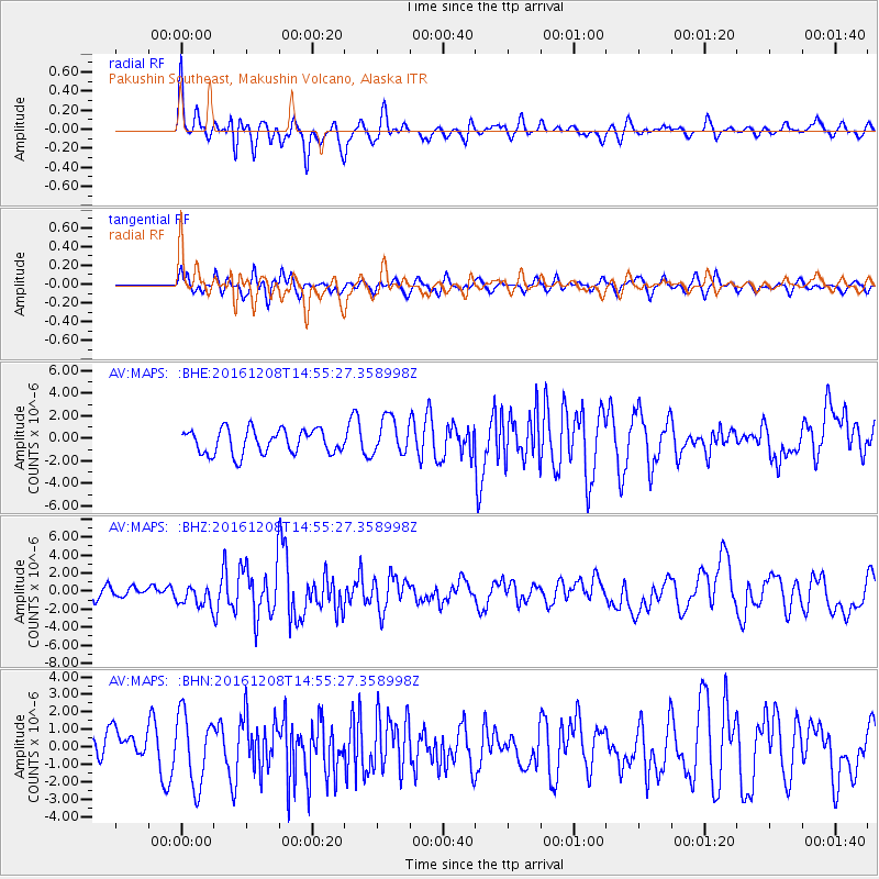
MAPS Pakushin Southeast, Makushin Volcano, Alaska - Earthquake Result Viewer
*The percent match for this event was below the threshold and hence no stack was calculated.
| Earthquake location: |
Off Coast Of Northern California |
| Earthquake latitude/longitude: |
40.5/-126.2 |
| Earthquake time(UTC): |
2016/12/08 (343) 14:49:46 GMT |
| Earthquake Depth: |
12 km |
| Earthquake Magnitude: |
6.5 Mwb |
| Earthquake Catalog/Contributor: |
NEIC PDE/us |
|
| Network: |
AV Alaska Volcano Observatory |
| Station: |
MAPS Pakushin Southeast, Makushin Volcano, Alaska |
| Lat/Lon: |
53.81 N/166.94 W |
| Elevation: |
333 m |
|
| Distance: |
30.3 deg |
| Az: |
309.892 deg |
| Baz: |
99.294 deg |
| Ray Param: |
$rayparam |
*The percent match for this event was below the threshold and hence was not used in the summary stack. |
|
| Radial Match: |
64.38861 % |
| Radial Bump: |
400 |
| Transverse Match: |
60.40672 % |
| Transverse Bump: |
400 |
| SOD ConfigId: |
11737051 |
| Insert Time: |
2019-04-26 05:50:13.196 +0000 |
| GWidth: |
2.5 |
| Max Bumps: |
400 |
| Tol: |
0.001 |
|
Signal To Noise
| Channel | StoN | STA | LTA |
| AV:MAPS: :BHZ:20161208T14:55:27.358998Z | 1.8272611 | 1.150962E-6 | 6.2988374E-7 |
| AV:MAPS: :BHN:20161208T14:55:27.358998Z | 2.807759 | 2.0229813E-6 | 7.2049676E-7 |
| AV:MAPS: :BHE:20161208T14:55:27.358998Z | 1.5188425 | 1.6395479E-6 | 1.0794721E-6 |
| Arrivals |
| Ps | |
| PpPs | |
| PsPs/PpSs | |


