You are here: Home > Network List > CN - Canadian National Seismograph Network Stations List
> Station FRB IQALUIT, N.W.T. > Earthquake Result Viewer
FRB IQALUIT, N.W.T. - Earthquake Result Viewer
| Earthquake location: |
Off Coast Of Northern California |
| Earthquake latitude/longitude: |
40.5/-126.2 |
| Earthquake time(UTC): |
2016/12/08 (343) 14:49:46 GMT |
| Earthquake Depth: |
12 km |
| Earthquake Magnitude: |
6.5 Mwb |
| Earthquake Catalog/Contributor: |
NEIC PDE/us |
|
| Network: |
CN Canadian National Seismograph Network |
| Station: |
FRB IQALUIT, N.W.T. |
| Lat/Lon: |
63.75 N/68.55 W |
| Elevation: |
18 m |
|
| Distance: |
40.5 deg |
| Az: |
35.361 deg |
| Baz: |
263.054 deg |
| Ray Param: |
0.07438558 |
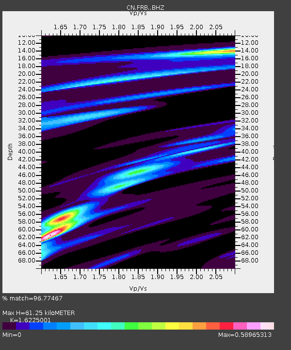
| Estimated Moho Depth: |
61.25 km |
| Estimated Crust Vp/Vs: |
1.62 |
| Assumed Crust Vp: |
6.419 km/s |
| Estimated Crust Vs: |
3.956 km/s |
| Estimated Crust Poisson's Ratio: |
0.19 |
|
| Radial Match: |
96.77467 % |
| Radial Bump: |
176 |
| Transverse Match: |
58.51184 % |
| Transverse Bump: |
400 |
| SOD ConfigId: |
11737051 |
| Insert Time: |
2019-04-26 05:50:54.934 +0000 |
| GWidth: |
2.5 |
| Max Bumps: |
400 |
| Tol: |
0.001 |
|

Signal To Noise
| Channel | StoN | STA | LTA |
| CN:FRB: :BHZ:20161208T14:56:54.175007Z | 3.7072518 | 1.7183762E-6 | 4.6351752E-7 |
| CN:FRB: :BHN:20161208T14:56:54.175007Z | 1.013085 | 2.6915055E-7 | 2.6567417E-7 |
| CN:FRB: :BHE:20161208T14:56:54.175007Z | 5.2478566 | 1.2127593E-6 | 2.3109612E-7 |
| Arrivals |
| Ps | 6.4 SECOND |
| PpPs | 23 SECOND |
| PsPs/PpSs | 30 SECOND |


