You are here: Home > Network List > CI - Caltech Regional Seismic Network Stations List
> Station FUR Furnace Creek, CA, USA > Earthquake Result Viewer
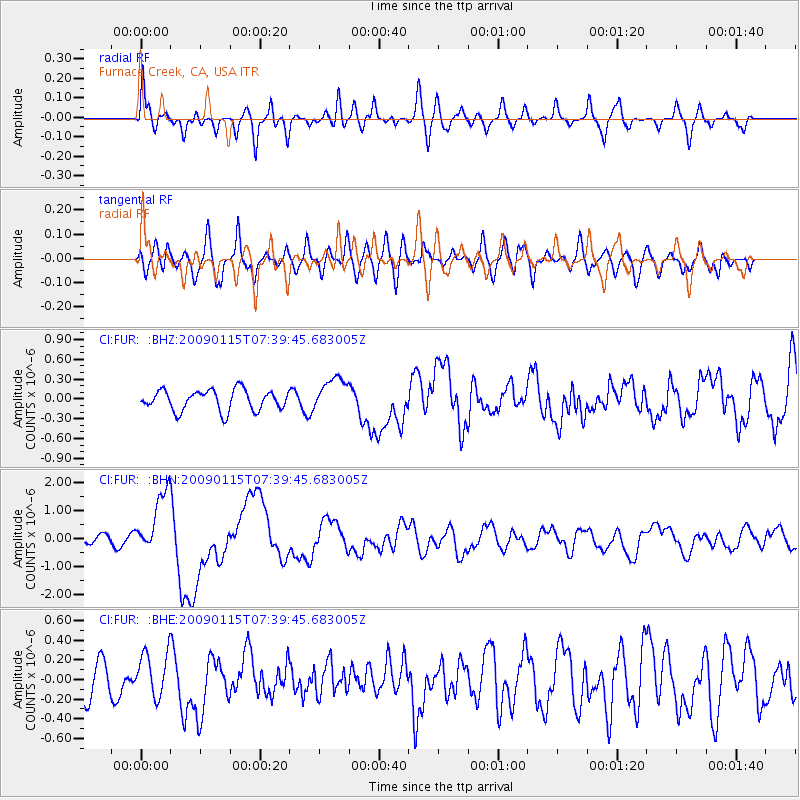
FUR Furnace Creek, CA, USA - Earthquake Result Viewer
*The percent match for this event was below the threshold and hence no stack was calculated.
| Earthquake location: |
Southeast Of Loyalty Islands |
| Earthquake latitude/longitude: |
-22.4/170.6 |
| Earthquake time(UTC): |
2009/01/15 (015) 07:27:20 GMT |
| Earthquake Depth: |
27 km |
| Earthquake Magnitude: |
5.8 MB, 6.5 MS, 6.7 MW, 6.6 MW |
| Earthquake Catalog/Contributor: |
WHDF/NEIC |
|
| Network: |
CI Caltech Regional Seismic Network |
| Station: |
FUR Furnace Creek, CA, USA |
| Lat/Lon: |
36.47 N/116.86 W |
| Elevation: |
-37.0 m |
|
| Distance: |
90.0 deg |
| Az: |
50.246 deg |
| Baz: |
241.997 deg |
| Ray Param: |
$rayparam |
*The percent match for this event was below the threshold and hence was not used in the summary stack. |
|
| Radial Match: |
68.491806 % |
| Radial Bump: |
400 |
| Transverse Match: |
69.40152 % |
| Transverse Bump: |
400 |
| SOD ConfigId: |
2834 |
| Insert Time: |
2010-03-05 20:17:02.567 +0000 |
| GWidth: |
2.5 |
| Max Bumps: |
400 |
| Tol: |
0.001 |
|
Signal To Noise
| Channel | StoN | STA | LTA |
| CI:FUR: :BHN:20090115T07:39:45.683005Z | 6.583255 | 1.1280526E-6 | 1.7135181E-7 |
| CI:FUR: :BHE:20090115T07:39:45.683005Z | 1.0222014 | 2.261014E-7 | 2.2119065E-7 |
| CI:FUR: :BHZ:20090115T07:39:45.683005Z | 1.6788166 | 2.610603E-7 | 1.5550258E-7 |
| Arrivals |
| Ps | |
| PpPs | |
| PsPs/PpSs | |


