You are here: Home > Network List > AU - Australian Seismological Centre Stations List
> Station PSAC1 Pilbara Seismic Array Element C1 > Earthquake Result Viewer
PSAC1 Pilbara Seismic Array Element C1 - Earthquake Result Viewer
| Earthquake location: |
Vanuatu Islands |
| Earthquake latitude/longitude: |
-14.8/167.3 |
| Earthquake time(UTC): |
2015/10/20 (293) 21:52:02 GMT |
| Earthquake Depth: |
127 km |
| Earthquake Magnitude: |
7.1 MWW, 7.3 MI |
| Earthquake Catalog/Contributor: |
NEIC PDE/NEIC COMCAT |
|
| Network: |
AU Australian Seismological Centre |
| Station: |
PSAC1 Pilbara Seismic Array Element C1 |
| Lat/Lon: |
21.53 S/119.81 E |
| Elevation: |
303 m |
|
| Distance: |
45.5 deg |
| Az: |
254.312 deg |
| Baz: |
89.885 deg |
| Ray Param: |
0.0708041 |
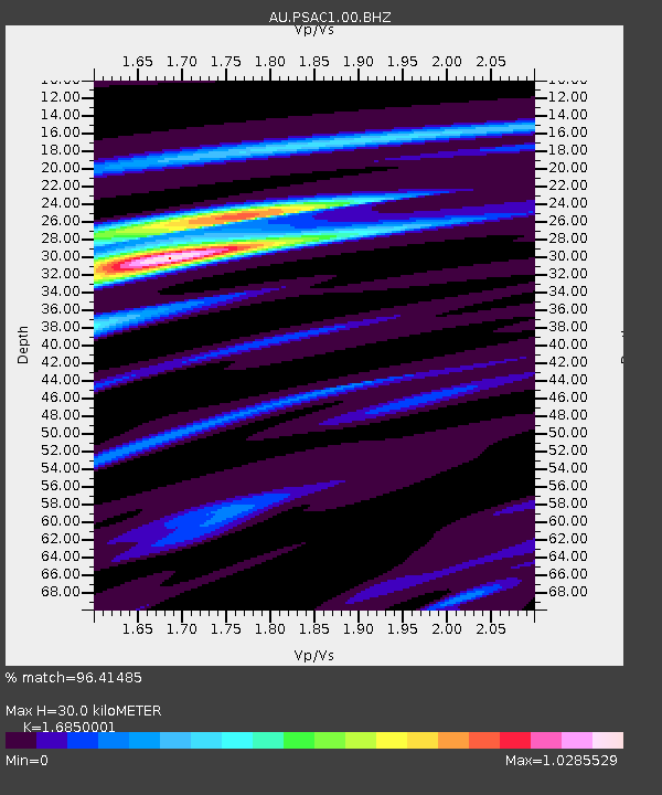
| Estimated Moho Depth: |
30.0 km |
| Estimated Crust Vp/Vs: |
1.69 |
| Assumed Crust Vp: |
6.464 km/s |
| Estimated Crust Vs: |
3.836 km/s |
| Estimated Crust Poisson's Ratio: |
0.23 |
|
| Radial Match: |
96.41485 % |
| Radial Bump: |
244 |
| Transverse Match: |
79.27066 % |
| Transverse Bump: |
400 |
| SOD ConfigId: |
1259291 |
| Insert Time: |
2015-11-03 22:17:19.564 +0000 |
| GWidth: |
2.5 |
| Max Bumps: |
400 |
| Tol: |
0.001 |
|

Signal To Noise
| Channel | StoN | STA | LTA |
| AU:PSAC1:00:BHZ:20151020T21:59:38.018994Z | 48.24753 | 1.1895041E-5 | 2.4654196E-7 |
| AU:PSAC1:00:BH1:20151020T21:59:38.018994Z | 3.0889008 | 5.459316E-7 | 1.7673977E-7 |
| AU:PSAC1:00:BH2:20151020T21:59:38.018994Z | 62.89342 | 7.823575E-6 | 1.2439418E-7 |
| Arrivals |
| Ps | 3.4 SECOND |
| PpPs | 12 SECOND |
| PsPs/PpSs | 15 SECOND |


